

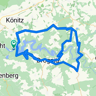
Hohenwarte 2011
A cycling route starting in Hohenwarte, Thuringia, Germany.
Overview
About this route
- -:--
- Duration
- 54.9 km
- Distance
- 988 m
- Ascent
- 988 m
- Descent
- ---
- Avg. speed
- ---
- Max. altitude
Route quality
Waytypes & surfaces along the route
Waytypes
Track
30.2 km
(55 %)
Path
10.4 km
(19 %)
Surfaces
Paved
11.5 km
(21 %)
Unpaved
37.3 km
(68 %)
Gravel
19.8 km
(36 %)
Ground
12.1 km
(22 %)
Continue with Bikemap
Use, edit, or download this cycling route
You would like to ride Hohenwarte 2011 or customize it for your own trip? Here is what you can do with this Bikemap route:
Free features
- Save this route as favorite or in collections
- Copy & plan your own version of this route
- Sync your route with Garmin or Wahoo
Premium features
Free trial for 3 days, or one-time payment. More about Bikemap Premium.
- Navigate this route on iOS & Android
- Export a GPX / KML file of this route
- Create your custom printout (try it for free)
- Download this route for offline navigation
Discover more Premium features.
Get Bikemap PremiumFrom our community
Other popular routes starting in Hohenwarte
 rund um den hohenwartestausee
- Distance
- 81.7 km
- Ascent
- 1,188 m
- Descent
- 1,206 m
- Location
- Hohenwarte, Thuringia, Germany
 Hochenwarte
- Distance
- 12.2 km
- Ascent
- 336 m
- Descent
- 325 m
- Location
- Hohenwarte, Thuringia, Germany
 Saaleradweg, Hohenwarte nach Am Hang 13, Saalfeld/Saale
- Distance
- 20.3 km
- Ascent
- 193 m
- Descent
- 228 m
- Location
- Hohenwarte, Thuringia, Germany
 Preßwitzer Spitze (Aussichtspunkt), Hohenwarte to Fritz-Ritter-Straße 44, Jena
- Distance
- 47.2 km
- Ascent
- 445 m
- Descent
- 577 m
- Location
- Hohenwarte, Thuringia, Germany
 Hohenwarte-Runde CLONED FROM ROUTE 87251
- Distance
- 47.4 km
- Ascent
- 961 m
- Descent
- 961 m
- Location
- Hohenwarte, Thuringia, Germany
 L2385, Hohenwarte nach L2385, Hohenwarte
- Distance
- 68.3 km
- Ascent
- 4,738 m
- Descent
- 4,738 m
- Location
- Hohenwarte, Thuringia, Germany
 Saaleradweg Etappe 2
- Distance
- 122.4 km
- Ascent
- 771 m
- Descent
- 1,076 m
- Location
- Hohenwarte, Thuringia, Germany
 Saaleradweg Etappe 2
- Distance
- 122.5 km
- Ascent
- 251 m
- Descent
- 589 m
- Location
- Hohenwarte, Thuringia, Germany
Open it in the app