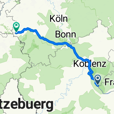
Rheingauer Riesling Route
- 70.9 km
- 407 m
- 338 m
- Kaub, Rhineland-Palatinate, Germany
Je mehr du hier schreibst, desto hilfreicher Mit einer Länge von 62 km führt die Rheingauer Riesling Route von Kaub durch den Rheingau bis Flörsheim am Main oder umgekehrt. Teils radeln Sie entlang des Rheins, teils durch die Weinberge und teils entlang des Mains. Während Ihrer Radtour können Sie zahlreiche Sehenswürdigkeiten besichtigen, wie die berühmte Drosselgasse in Rüdesheim am Rhein, das Kloster Eberbach und die kurfürstliche Burg in Eltville am Rhein, Schloss Vollrads, Schloss Johannisberg sowie zahlreiche Adelshöfe, Kirchen und Weindörfer. Natürlich bieten auch die verschiedenen Gutsschänken und Winzerhöfe entlang der Strecke die Möglichkeit zur Rast. Die Rheingauer Riesling Route ist mit dem Rheingauer Römer ausgeschildert und verfügt über leichte Steigungen. Besonders Sehenswert ist die 26 Kilometer lange Strecke von Rüdesheim am Rhein über Walluf nach Wiesbaden/Schierstein, die hauptsächlich durch die Weinberge führt.
Quiet road
20.6 km29 %Track
20.6 km29 %Paved
62.4 km(88 %)Unpaved
4.3 km(6 %)Asphalt
51.8 km73 %Concrete
8.5 km12 %Free trial for 3 days, or one-time payment. More about Bikemap Premium.
Discover more Premium features.
Get Bikemap PremiumOpen it in the app