

Benicasim-Oropesa 2010
A cycling route starting in Benicassim, Valencia, Spain.
Overview
About this route
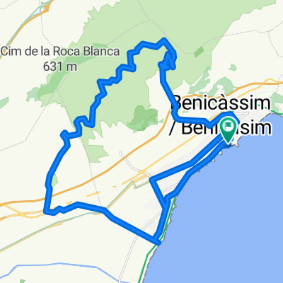
Departure from Benicasim, we start on the Green Way between Benicasim and Oropesa, halfway we turn left and after crossing the highway, we begin a beautiful ascent until we reach the geodetic point with wonderful views of the entire coast of Castellón. We start to descend to the first intersection where we turn right taking a trail, and once down all is flat passing through Oropesa and taking the Green Way again to arrive at Benicasim.(12/06/2010)
- -:--
- Duration
- 32.6 km
- Distance
- 562 m
- Ascent
- 555 m
- Descent
- ---
- Avg. speed
- ---
- Max. altitude

Continue with Bikemap
Use, edit, or download this cycling route
You would like to ride Benicasim-Oropesa 2010 or customize it for your own trip? Here is what you can do with this Bikemap route:
Free features
- Save this route as favorite or in collections
- Copy & plan your own version of this route
- Sync your route with Garmin or Wahoo
Premium features
Free trial for 3 days, or one-time payment. More about Bikemap Premium.
- Navigate this route on iOS & Android
- Export a GPX / KML file of this route
- Create your custom printout (try it for free)
- Download this route for offline navigation
Discover more Premium features.
Get Bikemap PremiumFrom our community
Other popular routes starting in Benicassim
 recorrido bici 44.2 km
- Distance
- 44.2 km
- Ascent
- 503 m
- Descent
- 500 m
- Location
- Benicassim, Valencia, Spain
 orpesa
- Distance
- 10.1 km
- Ascent
- 139 m
- Descent
- 141 m
- Location
- Benicassim, Valencia, Spain
 recorrido bici 40.1 km
- Distance
- 40.2 km
- Ascent
- 446 m
- Descent
- 444 m
- Location
- Benicassim, Valencia, Spain
 Spanien Benicassim
- Distance
- 14.9 km
- Ascent
- 355 m
- Descent
- 356 m
- Location
- Benicassim, Valencia, Spain
 Benicasim-Oropesa 2010
- Distance
- 32.6 km
- Ascent
- 562 m
- Descent
- 555 m
- Location
- Benicassim, Valencia, Spain
 Culla-Tirig desde Benicasim
- Distance
- 164.1 km
- Ascent
- 1,581 m
- Descent
- 1,585 m
- Location
- Benicassim, Valencia, Spain
 Subida a las antenas del Bartolo 2010
- Distance
- 24.5 km
- Ascent
- 822 m
- Descent
- 822 m
- Location
- Benicassim, Valencia, Spain
 1º etapa castello 2014
- Distance
- 3 km
- Ascent
- 43 m
- Descent
- 52 m
- Location
- Benicassim, Valencia, Spain
Open it in the app