

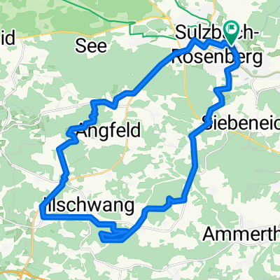
Sulzbach-Rosenberg -> Uffing_am_Staffelsee
A cycling route starting in Sulzbach-Rosenberg, Bavaria, Germany.
Overview
About this route
Challenging road cycling route from the heart of the Upper Palatinate, Sulzbach-Rosenberg, to Upper Bavaria, Uffing am Staffelsee
Due to heavy traffic in some sections, it's best to ride on weekends!
- -:--
- Duration
- 249.9 km
- Distance
- 800 m
- Ascent
- 592 m
- Descent
- ---
- Avg. speed
- ---
- Max. altitude
Route quality
Waytypes & surfaces along the route
Waytypes
Path
55 km
(22 %)
Quiet road
47.5 km
(19 %)
Surfaces
Paved
214.9 km
(86 %)
Unpaved
10 km
(4 %)
Asphalt
209.9 km
(84 %)
Gravel
7.5 km
(3 %)
Continue with Bikemap
Use, edit, or download this cycling route
You would like to ride Sulzbach-Rosenberg -> Uffing_am_Staffelsee or customize it for your own trip? Here is what you can do with this Bikemap route:
Free features
- Save this route as favorite or in collections
- Copy & plan your own version of this route
- Split it into stages to create a multi-day tour
- Sync your route with Garmin or Wahoo
Premium features
Free trial for 3 days, or one-time payment. More about Bikemap Premium.
- Navigate this route on iOS & Android
- Export a GPX / KML file of this route
- Create your custom printout (try it for free)
- Download this route for offline navigation
Discover more Premium features.
Get Bikemap PremiumFrom our community
Other popular routes starting in Sulzbach-Rosenberg
 Drei Bergfesttour rund um Hahnbach
- Distance
- 46.7 km
- Ascent
- 628 m
- Descent
- 642 m
- Location
- Sulzbach-Rosenberg, Bavaria, Germany
 % Flüsse Radweg,Vilstal bis Kallmünz
- Distance
- 60.7 km
- Ascent
- 489 m
- Descent
- 569 m
- Location
- Sulzbach-Rosenberg, Bavaria, Germany
 SuRo - Osterhöhle - Hohe Zant - SuRo
- Distance
- 31.9 km
- Ascent
- 563 m
- Descent
- 560 m
- Location
- Sulzbach-Rosenberg, Bavaria, Germany
 Sulzbach-Rosenberg bis Kallmünz
- Distance
- 53.5 km
- Ascent
- 864 m
- Descent
- 921 m
- Location
- Sulzbach-Rosenberg, Bavaria, Germany
 rund um Sulzbach
- Distance
- 35.4 km
- Ascent
- 258 m
- Descent
- 260 m
- Location
- Sulzbach-Rosenberg, Bavaria, Germany
 Tour 3 (Landkreis Amberg-Sulzbach)
- Distance
- 38.9 km
- Ascent
- 495 m
- Descent
- 498 m
- Location
- Sulzbach-Rosenberg, Bavaria, Germany
 Schlangenfichte
- Distance
- 85.2 km
- Ascent
- 785 m
- Descent
- 782 m
- Location
- Sulzbach-Rosenberg, Bavaria, Germany
 Sieben Quellen
- Distance
- 27.8 km
- Ascent
- 482 m
- Descent
- 483 m
- Location
- Sulzbach-Rosenberg, Bavaria, Germany
Open it in the app