

Szosowa 60-tka - propozycja trasy od GreeneBikes.pl
A cycling route starting in Sobótka, Lower Silesian Voivodeship, Poland.
Overview
About this route
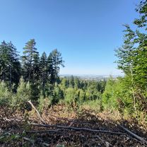
Proponowana trasa wiedzie w większości mało uczęszczanymi przez auta drogami, jednakże z uwagi na brak wydzielonych dróg rowerowych należy zachować wzmożoną ostrożność - fragmenty są dosyć ruchliwe. Z wielu miejsc trasy piękne widoki na Masyw Ślęży. Trasa wiedzie przez znaną w okolicy i często odwiedzane przez rowerzystów miejsca jak zalew Mietkowski oraz przełęcz Tąpadła.
- -:--
- Duration
- 62.1 km
- Distance
- 375 m
- Ascent
- 374 m
- Descent
- ---
- Avg. speed
- 378 m
- Max. altitude

Route quality
Waytypes & surfaces along the route
Waytypes
Road
56.5 km
(91 %)
Quiet road
4.3 km
(7 %)
Surfaces
Paved
15.5 km
(25 %)
Unpaved
0.6 km
(1 %)
Asphalt
15.5 km
(25 %)
Unpaved (undefined)
0.6 km
(1 %)
Undefined
46 km
(74 %)
Continue with Bikemap
Use, edit, or download this cycling route
You would like to ride Szosowa 60-tka - propozycja trasy od GreeneBikes.pl or customize it for your own trip? Here is what you can do with this Bikemap route:
Free features
- Save this route as favorite or in collections
- Copy & plan your own version of this route
- Sync your route with Garmin or Wahoo
Premium features
Free trial for 3 days, or one-time payment. More about Bikemap Premium.
- Navigate this route on iOS & Android
- Export a GPX / KML file of this route
- Create your custom printout (try it for free)
- Download this route for offline navigation
Discover more Premium features.
Get Bikemap PremiumFrom our community
Other popular routes starting in Sobótka
 al. św. Anny do al. św. Anny
- Distance
- 36.3 km
- Ascent
- 645 m
- Descent
- 683 m
- Location
- Sobótka, Lower Silesian Voivodeship, Poland
 Przy Tamie 4, Borzygniew do Przy Tamie 4, Borzygniew
- Distance
- 18.7 km
- Ascent
- 109 m
- Descent
- 160 m
- Location
- Sobótka, Lower Silesian Voivodeship, Poland
 tapa wro
- Distance
- 46.4 km
- Ascent
- 71 m
- Descent
- 327 m
- Location
- Sobótka, Lower Silesian Voivodeship, Poland
 Wrocławska, Rogów Sobócki do Jutrzenki, Sulistrowice
- Distance
- 10.7 km
- Ascent
- 298 m
- Descent
- 211 m
- Location
- Sobótka, Lower Silesian Voivodeship, Poland
 MTB #1 - propozycja trasy od GreeneBikes.pl
- Distance
- 34 km
- Ascent
- 2,670 m
- Descent
- 2,670 m
- Location
- Sobótka, Lower Silesian Voivodeship, Poland
 Relaxed Morning Ride In Marcinowice
- Distance
- 7.4 km
- Ascent
- 46 m
- Descent
- 48 m
- Location
- Sobótka, Lower Silesian Voivodeship, Poland
 rowerowa Ślęża - Family 1
- Distance
- 19.4 km
- Ascent
- 292 m
- Descent
- 341 m
- Location
- Sobótka, Lower Silesian Voivodeship, Poland
 chujnia po dziurach
- Distance
- 21 km
- Ascent
- 337 m
- Descent
- 337 m
- Location
- Sobótka, Lower Silesian Voivodeship, Poland
Open it in the app