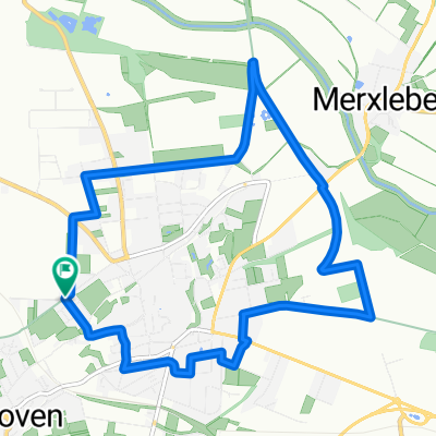
1.Tag der 3-Tage Tour durch den Hainich
A cycling route starting in Bad Langensalza, Free State of Thuringia, Germany.
Overview
About this route
Start war am Bahnhof in Bad Langensalza, dann ging es immer der gelben Route entlang.
Auf den Baumkronenpfad konnte man die herrliche Aussicht geniessen.
Danach fuhren wir weiter bis zur Jugendherrberge "Urwald-Life-Camp".
Dort haben wir sehr gut übernachtet.
- -:--
- Duration
- 25.4 km
- Distance
- 351 m
- Ascent
- 197 m
- Descent
- ---
- Avg. speed
- ---
- Avg. speed
Route quality
Waytypes & surfaces along the route
Waytypes
Track
17.9 km
(71 %)
Quiet road
4.1 km
(16 %)
Surfaces
Paved
7.8 km
(31 %)
Unpaved
14.1 km
(56 %)
Gravel
13.8 km
(55 %)
Asphalt
5.3 km
(21 %)
Continue with Bikemap
Use, edit, or download this cycling route
You would like to ride 1.Tag der 3-Tage Tour durch den Hainich or customize it for your own trip? Here is what you can do with this Bikemap route:
Free features
- Save this route as favorite or in collections
- Copy & plan your own version of this route
- Sync your route with Garmin or Wahoo
Premium features
Free trial for 3 days, or one-time payment. More about Bikemap Premium.
- Navigate this route on iOS & Android
- Export a GPX / KML file of this route
- Create your custom printout (try it for free)
- Download this route for offline navigation
Discover more Premium features.
Get Bikemap PremiumFrom our community
Other popular routes starting in Bad Langensalza
- Hainich Bad Langensalza - Creutzburg - Hörschel - Eisenach
- Distance
- 51.7 km
- Ascent
- 586 m
- Descent
- 549 m
- Location
- Bad Langensalza, Free State of Thuringia, Germany
- 2017 Unstrut Nagelstädt-Großvargula
- Distance
- 40.8 km
- Ascent
- 268 m
- Descent
- 267 m
- Location
- Bad Langensalza, Free State of Thuringia, Germany
- 2016-07-16: Unstrut - Hainich (gelb, rot) - Unstrut
- Distance
- 75.2 km
- Ascent
- 358 m
- Descent
- 355 m
- Location
- Bad Langensalza, Free State of Thuringia, Germany
- Thamsbrück - Hippach
- Distance
- 568 km
- Ascent
- 1,720 m
- Descent
- 1,291 m
- Location
- Bad Langensalza, Free State of Thuringia, Germany
- LSZ, Craulaer Kreuz, Rennstieg, Eigenrieden, Mühlhausen, LSZ
- Distance
- 80.2 km
- Ascent
- 526 m
- Descent
- 526 m
- Location
- Bad Langensalza, Free State of Thuringia, Germany
- LSZ - SW-Runde 1
- Distance
- 21.6 km
- Ascent
- 197 m
- Descent
- 200 m
- Location
- Bad Langensalza, Free State of Thuringia, Germany
- 1.Tag der 3-Tage Tour durch den Hainich
- Distance
- 25.4 km
- Ascent
- 351 m
- Descent
- 197 m
- Location
- Bad Langensalza, Free State of Thuringia, Germany
- Tour durch den Hainich
- Distance
- 67 km
- Ascent
- 415 m
- Descent
- 422 m
- Location
- Bad Langensalza, Free State of Thuringia, Germany
Open it in the app