
2.Tag der 3-Tage Tour durch den Hainich
A cycling route starting in Lauterbach, Thuringia, Germany.
Overview
About this route
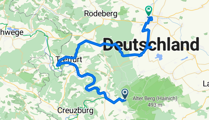
<p>On the second day, we started at the youth hostel in Lauterbach. We then followed the Werra Valley cycle path all the way past Treffurt. Near Heldra, we switched to the Unstrut-Werra cycle route towards Mühlhausen. We stopped for lunch at Heyerode station and cycled to the geographical centre of Germany in Niederdorla. For the night, we had chosen the youth hostel in Mühlhausen.</p>
Translated, show original (German)- -:--
- Duration
- 55.9 km
- Distance
- 390 m
- Ascent
- 528 m
- Descent
- ---
- Avg. speed
- ---
- Max. altitude

Route quality
Waytypes & surfaces along the route
Waytypes
Track
16.8 km
(30 %)
Quiet road
16.2 km
(29 %)
Surfaces
Paved
30.2 km
(54 %)
Unpaved
13.4 km
(24 %)
Asphalt
26.3 km
(47 %)
Gravel
8.4 km
(15 %)
Continue with Bikemap
Use, edit, or download this cycling route
You would like to ride 2.Tag der 3-Tage Tour durch den Hainich or customize it for your own trip? Here is what you can do with this Bikemap route:
Free features
- Save this route as favorite or in collections
- Copy & plan your own version of this route
- Sync your route with Garmin or Wahoo
Premium features
Free trial for 3 days, or one-time payment. More about Bikemap Premium.
- Navigate this route on iOS & Android
- Export a GPX / KML file of this route
- Create your custom printout (try it for free)
- Download this route for offline navigation
Discover more Premium features.
Get Bikemap PremiumFrom our community
Other popular routes starting in Lauterbach
 RR Thür Mihla -Hainich 78km 900HM
- Distance
- 78 km
- Ascent
- 646 m
- Descent
- 683 m
- Location
- Lauterbach, Thuringia, Germany
 Im Rieth, Bischofroda-Johannisplatz 12–20, Eisenach
- Distance
- 13.2 km
- Ascent
- 154 m
- Descent
- 143 m
- Location
- Lauterbach, Thuringia, Germany
 Urwald-Life-Camp - Baumkronenpfad
- Distance
- 36.4 km
- Ascent
- 465 m
- Descent
- 484 m
- Location
- Lauterbach, Thuringia, Germany
 Kurze Ausfahrt von Lauterbach nach Mihla
- Distance
- 3.8 km
- Ascent
- 102 m
- Descent
- 98 m
- Location
- Lauterbach, Thuringia, Germany
 CH - DE 04
- Distance
- 100.3 km
- Ascent
- 783 m
- Descent
- 787 m
- Location
- Lauterbach, Thuringia, Germany
 Rundfahrt Mihla Mühlhausen Treffurt Mihla
- Distance
- 74.9 km
- Ascent
- 613 m
- Descent
- 686 m
- Location
- Lauterbach, Thuringia, Germany
 Himmelfahrtstour
- Distance
- 41.8 km
- Ascent
- 302 m
- Descent
- 302 m
- Location
- Lauterbach, Thuringia, Germany
 2.Tag der 3-Tage Tour durch den Hainich
- Distance
- 55.9 km
- Ascent
- 390 m
- Descent
- 528 m
- Location
- Lauterbach, Thuringia, Germany
Open it in the app