

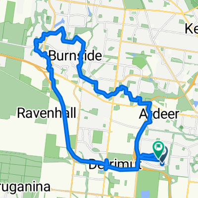
Maribyrnong River Loop 50k
A cycling route starting in Sunshine West, Victoria, Australia.
Overview
About this route
- -:--
- Duration
- 50.5 km
- Distance
- 156 m
- Ascent
- 152 m
- Descent
- ---
- Avg. speed
- 60 m
- Max. altitude

Route quality
Waytypes & surfaces along the route
Waytypes
Cycleway
36.3 km
(72 %)
Quiet road
9.1 km
(18 %)
Surfaces
Paved
37.4 km
(74 %)
Unpaved
9.1 km
(18 %)
Asphalt
18.2 km
(36 %)
Paved (undefined)
12.1 km
(24 %)
Continue with Bikemap
Use, edit, or download this cycling route
You would like to ride Maribyrnong River Loop 50k or customize it for your own trip? Here is what you can do with this Bikemap route:
Free features
- Save this route as favorite or in collections
- Copy & plan your own version of this route
- Sync your route with Garmin or Wahoo
Premium features
Free trial for 3 days, or one-time payment. More about Bikemap Premium.
- Navigate this route on iOS & Android
- Export a GPX / KML file of this route
- Create your custom printout (try it for free)
- Download this route for offline navigation
Discover more Premium features.
Get Bikemap PremiumFrom our community
Other popular routes starting in Sunshine West
 Mailey Street 26A, Sunshine West to Mailey Street 26A, Sunshine West
- Distance
- 51 km
- Ascent
- 3 m
- Descent
- 4 m
- Location
- Sunshine West, Victoria, Australia
 Maribyrnong Highpoint Loop 38k
- Distance
- 37.3 km
- Ascent
- 347 m
- Descent
- 344 m
- Location
- Sunshine West, Victoria, Australia
 Caleb Loop 30k
- Distance
- 30.2 km
- Ascent
- 80 m
- Descent
- 78 m
- Location
- Sunshine West, Victoria, Australia
 Hm Sth Altona Loop 34k
- Distance
- 33.9 km
- Ascent
- 128 m
- Descent
- 131 m
- Location
- Sunshine West, Victoria, Australia
 Sunshine West Caroline Springs LOOP
- Distance
- 33.7 km
- Ascent
- 100 m
- Descent
- 108 m
- Location
- Sunshine West, Victoria, Australia
 Maribyrnong River Loop 50k
- Distance
- 50.5 km
- Ascent
- 156 m
- Descent
- 152 m
- Location
- Sunshine West, Victoria, Australia
 ride to the park
- Distance
- 6.4 km
- Ascent
- 42 m
- Descent
- 44 m
- Location
- Sunshine West, Victoria, Australia
 34 Allison St, Sunshine West to 10 Corella Rd, Sunshine West
- Distance
- 30.8 km
- Ascent
- 99 m
- Descent
- 104 m
- Location
- Sunshine West, Victoria, Australia
Open it in the app