Planung Muehltal - Tanneberg
A cycling route starting in Weißenborn, Thuringia, Germany.
Overview
About this route
- -:--
- Duration
- 88.8 km
- Distance
- 599 m
- Ascent
- 615 m
- Descent
- ---
- Avg. speed
- ---
- Max. altitude
Route quality
Waytypes & surfaces along the route
Waytypes
Road
36.4 km
(41 %)
Quiet road
13.3 km
(15 %)
Surfaces
Paved
56 km
(63 %)
Unpaved
4.4 km
(5 %)
Asphalt
53.3 km
(60 %)
Paved (undefined)
2.7 km
(3 %)
Continue with Bikemap
Use, edit, or download this cycling route
You would like to ride Planung Muehltal - Tanneberg or customize it for your own trip? Here is what you can do with this Bikemap route:
Free features
- Save this route as favorite or in collections
- Copy & plan your own version of this route
- Split it into stages to create a multi-day tour
- Sync your route with Garmin or Wahoo
Premium features
Free trial for 3 days, or one-time payment. More about Bikemap Premium.
- Navigate this route on iOS & Android
- Export a GPX / KML file of this route
- Create your custom printout (try it for free)
- Download this route for offline navigation
Discover more Premium features.
Get Bikemap PremiumFrom our community
Other popular routes starting in Weißenborn
- 20170626_100830.gpx
- Distance
- 36.6 km
- Ascent
- 204 m
- Descent
- 286 m
- Location
- Weißenborn, Thuringia, Germany
- Mühltalschleife über Seifartsdorf
- Distance
- 22.6 km
- Ascent
- 221 m
- Descent
- 233 m
- Location
- Weißenborn, Thuringia, Germany
- Mühltal
- Distance
- 21.2 km
- Ascent
- 88 m
- Descent
- 203 m
- Location
- Weißenborn, Thuringia, Germany
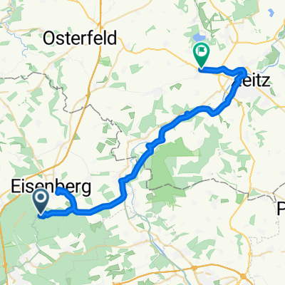
- Mühltal lang Bettina
- Distance
- 51.4 km
- Ascent
- 280 m
- Descent
- 278 m
- Location
- Weißenborn, Thuringia, Germany
- mühltal
- Distance
- 30 km
- Ascent
- 214 m
- Descent
- 217 m
- Location
- Weißenborn, Thuringia, Germany
- Mühltal 12, Weißenborn nach Eichenstraße 22, Gera
- Distance
- 29 km
- Ascent
- 150 m
- Descent
- 258 m
- Location
- Weißenborn, Thuringia, Germany
- Mühltal 12, Weißenborn nach Eichenstraße 22, Gera
- Distance
- 30.1 km
- Ascent
- 70 m
- Descent
- 191 m
- Location
- Weißenborn, Thuringia, Germany
- Werra-ThüS-5.Tag
- Distance
- 99.4 km
- Ascent
- 369 m
- Descent
- 457 m
- Location
- Weißenborn, Thuringia, Germany
Open it in the app