

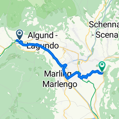
Da Via San Ippolito 14, Lagundo a Via San Ippolito 23, Lagundo
A cycling route starting in Algund, Trentino-Alto Adige, Italy.
Overview
About this route
- 5 h 37 min
- Duration
- 36.8 km
- Distance
- 814 m
- Ascent
- 854 m
- Descent
- 6.6 km/h
- Avg. speed
- ---
- Max. altitude

Route quality
Waytypes & surfaces along the route
Waytypes
Cycleway
18.8 km
(51 %)
Quiet road
7.7 km
(21 %)
Surfaces
Paved
28.7 km
(78 %)
Unpaved
0.4 km
(1 %)
Asphalt
28.4 km
(77 %)
Paved (undefined)
0.4 km
(1 %)
Continue with Bikemap
Use, edit, or download this cycling route
You would like to ride Da Via San Ippolito 14, Lagundo a Via San Ippolito 23, Lagundo or customize it for your own trip? Here is what you can do with this Bikemap route:
Free features
- Save this route as favorite or in collections
- Copy & plan your own version of this route
- Sync your route with Garmin or Wahoo
Premium features
Free trial for 3 days, or one-time payment. More about Bikemap Premium.
- Navigate this route on iOS & Android
- Export a GPX / KML file of this route
- Create your custom printout (try it for free)
- Download this route for offline navigation
Discover more Premium features.
Get Bikemap PremiumFrom our community
Other popular routes starting in Algund
 Algunder Runde
- Distance
- 26.2 km
- Ascent
- 1,256 m
- Descent
- 1,255 m
- Location
- Algund, Trentino-Alto Adige, Italy
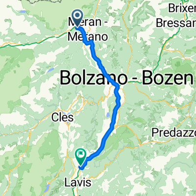 Meran - San Michele all'Adige
- Distance
- 71.2 km
- Ascent
- 236 m
- Descent
- 422 m
- Location
- Algund, Trentino-Alto Adige, Italy
 Tuscia!
- Distance
- 1,299.3 km
- Ascent
- 4,116 m
- Descent
- 4,381 m
- Location
- Algund, Trentino-Alto Adige, Italy
 Algund Falzeben 2
- Distance
- 19.7 km
- Ascent
- 1,355 m
- Descent
- 27 m
- Location
- Algund, Trentino-Alto Adige, Italy
 RR_2013_Traininngslager_04
- Distance
- 94.7 km
- Ascent
- 2,756 m
- Descent
- 2,749 m
- Location
- Algund, Trentino-Alto Adige, Italy
 Route zu P1 Schloss Trauttmansdorff - P1 Castel Trauttmansdorff
- Distance
- 11.1 km
- Ascent
- 108 m
- Descent
- 261 m
- Location
- Algund, Trentino-Alto Adige, Italy
 Bergtour über Gampenjoch und Meldelpass
- Distance
- 102.7 km
- Ascent
- 1,751 m
- Descent
- 1,751 m
- Location
- Algund, Trentino-Alto Adige, Italy
 Gasthof Brünnl
- Distance
- 9.5 km
- Ascent
- 434 m
- Descent
- 2 m
- Location
- Algund, Trentino-Alto Adige, Italy
Open it in the app