

Lisac - Radovan - Lisac
A cycling route starting in Novi Travnik, Federation of Bosnia and Herzegovina, Bosnia and Herzegovina.
Overview
About this route
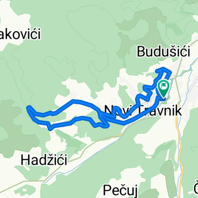
Route to Radovan Lake on Pavlovica mountain, at the top of Rostovo pass, in the wilderness.
The climb is moderately challenging, more than half of the way is asphalt. The second part of the climb is dirt road and forest. In places, you have to push.
The lake is surrounded by great trails for jumps and tricks, as well as a wonderful resting place.
The descent is on a different path along a stream to the village, through dense forest. There is a path, but it is very rocky, strong arms and good brakes are needed.
Good luck
- -:--
- Duration
- 15.2 km
- Distance
- 519 m
- Ascent
- 517 m
- Descent
- ---
- Avg. speed
- 1,255 m
- Max. altitude

Continue with Bikemap
Use, edit, or download this cycling route
You would like to ride Lisac - Radovan - Lisac or customize it for your own trip? Here is what you can do with this Bikemap route:
Free features
- Save this route as favorite or in collections
- Copy & plan your own version of this route
- Sync your route with Garmin or Wahoo
Premium features
Free trial for 3 days, or one-time payment. More about Bikemap Premium.
- Navigate this route on iOS & Android
- Export a GPX / KML file of this route
- Create your custom printout (try it for free)
- Download this route for offline navigation
Discover more Premium features.
Get Bikemap PremiumFrom our community
Other popular routes starting in Novi Travnik
 Novi Travnik to Novi Travnik
- Distance
- 36.7 km
- Ascent
- 630 m
- Descent
- 663 m
- Location
- Novi Travnik, Federation of Bosnia and Herzegovina, Bosnia and Herzegovina
 travnik
- Distance
- 28 km
- Ascent
- 1,105 m
- Descent
- 1,594 m
- Location
- Novi Travnik, Federation of Bosnia and Herzegovina, Bosnia and Herzegovina
 Westbalkan-Tour Deutschland - Bosnien 6. Etappe
- Distance
- 178.7 km
- Ascent
- 2,104 m
- Descent
- 2,555 m
- Location
- Novi Travnik, Federation of Bosnia and Herzegovina, Bosnia and Herzegovina
 Mirkova staza
- Distance
- 19.6 km
- Ascent
- 275 m
- Descent
- 275 m
- Location
- Novi Travnik, Federation of Bosnia and Herzegovina, Bosnia and Herzegovina
 Uzduž i poprijeko NT
- Distance
- 13 km
- Ascent
- 282 m
- Descent
- 284 m
- Location
- Novi Travnik, Federation of Bosnia and Herzegovina, Bosnia and Herzegovina
 heehsh
- Distance
- 25.7 km
- Ascent
- 1,150 m
- Descent
- 1,605 m
- Location
- Novi Travnik, Federation of Bosnia and Herzegovina, Bosnia and Herzegovina
 Lisac - Radovan - Lisac
- Distance
- 15.2 km
- Ascent
- 519 m
- Descent
- 517 m
- Location
- Novi Travnik, Federation of Bosnia and Herzegovina, Bosnia and Herzegovina
 Novi Travnik-Slimena-Putićevo-Bukovica-Kapelica-Mosor-Guča Gora-Nova Bila-Nević Polje-Novi Travnik
- Distance
- 43.2 km
- Ascent
- 798 m
- Descent
- 796 m
- Location
- Novi Travnik, Federation of Bosnia and Herzegovina, Bosnia and Herzegovina
Open it in the app