

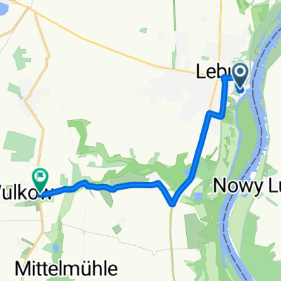
Route nach Lebus-Busch, Lebus
A cycling route starting in Lebus, Brandenburg, Germany.
Overview
About this route
- 15 min
- Duration
- 3.1 km
- Distance
- 6 m
- Ascent
- 30 m
- Descent
- 12.3 km/h
- Avg. speed
- ---
- Max. altitude
Continue with Bikemap
Use, edit, or download this cycling route
You would like to ride Route nach Lebus-Busch, Lebus or customize it for your own trip? Here is what you can do with this Bikemap route:
Free features
- Save this route as favorite or in collections
- Copy & plan your own version of this route
- Sync your route with Garmin or Wahoo
Premium features
Free trial for 3 days, or one-time payment. More about Bikemap Premium.
- Navigate this route on iOS & Android
- Export a GPX / KML file of this route
- Create your custom printout (try it for free)
- Download this route for offline navigation
Discover more Premium features.
Get Bikemap PremiumFrom our community
Other popular routes starting in Lebus
 Busch 2C, Lebus nach Birkenweg 11, Reitwein
- Distance
- 10.7 km
- Ascent
- 12 m
- Descent
- 14 m
- Location
- Lebus, Brandenburg, Germany
 Breite Straße 18, Lebus nach Neuglietzener Straße 42, Bad Freienwalde (Oder)
- Distance
- 72.3 km
- Ascent
- 339 m
- Descent
- 358 m
- Location
- Lebus, Brandenburg, Germany
 Oderradweg
- Distance
- 112.9 km
- Ascent
- 200 m
- Descent
- 196 m
- Location
- Lebus, Brandenburg, Germany
 Wulkow-Dolgelin-Reitwein-Mallnow
- Distance
- 56.6 km
- Ascent
- 126 m
- Descent
- 130 m
- Location
- Lebus, Brandenburg, Germany
 Hintergasse 2A, Lebus nach Hintergasse 2A, Lebus
- Distance
- 72.2 km
- Ascent
- 54 m
- Descent
- 55 m
- Location
- Lebus, Brandenburg, Germany
 Route im Schneckentempo in Lebus
- Distance
- 7.5 km
- Ascent
- 80 m
- Descent
- 60 m
- Location
- Lebus, Brandenburg, Germany
 Lebus - Parsteiner See
- Distance
- 108.6 km
- Ascent
- 134 m
- Descent
- 98 m
- Location
- Lebus, Brandenburg, Germany
 Oderradweg 13, Von Lebus nach Hohenwutzen
- Distance
- 87.1 km
- Ascent
- 52 m
- Descent
- 70 m
- Location
- Lebus, Brandenburg, Germany
Open it in the app