

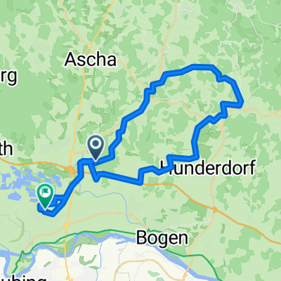
Steinach MTB
A cycling route starting in Steinach, Bavaria, Germany.
Overview
About this route
Asphalt, Schotter, Singletrails :-)
- -:--
- Duration
- 43.2 km
- Distance
- 696 m
- Ascent
- 696 m
- Descent
- ---
- Avg. speed
- ---
- Max. altitude
Route quality
Waytypes & surfaces along the route
Waytypes
Track
22 km
(51 %)
Quiet road
13.4 km
(31 %)
Surfaces
Paved
12.1 km
(28 %)
Unpaved
25.9 km
(60 %)
Asphalt
12.1 km
(28 %)
Loose gravel
10.8 km
(25 %)
Continue with Bikemap
Use, edit, or download this cycling route
You would like to ride Steinach MTB or customize it for your own trip? Here is what you can do with this Bikemap route:
Free features
- Save this route as favorite or in collections
- Copy & plan your own version of this route
- Sync your route with Garmin or Wahoo
Premium features
Free trial for 3 days, or one-time payment. More about Bikemap Premium.
- Navigate this route on iOS & Android
- Export a GPX / KML file of this route
- Create your custom printout (try it for free)
- Download this route for offline navigation
Discover more Premium features.
Get Bikemap PremiumFrom our community
Other popular routes starting in Steinach
 Steinach MTB
- Distance
- 43.2 km
- Ascent
- 696 m
- Descent
- 696 m
- Location
- Steinach, Bavaria, Germany
 In der Spreiz 1, Steinach to In der Spreiz 1, Steinach
- Distance
- 16.7 km
- Ascent
- 77 m
- Descent
- 79 m
- Location
- Steinach, Bavaria, Germany
 Hofmarkstraße 7, Steinach nach Donaustraße 23, Passau
- Distance
- 104.6 km
- Ascent
- 409 m
- Descent
- 449 m
- Location
- Steinach, Bavaria, Germany
 Steinach - Hofdorf - Steinach
- Distance
- 28.9 km
- Ascent
- 106 m
- Descent
- 106 m
- Location
- Steinach, Bavaria, Germany
 Feierabendroute
- Distance
- 13.9 km
- Ascent
- 270 m
- Descent
- 270 m
- Location
- Steinach, Bavaria, Germany
 Hochstraß 9, Steinach nach Grubhöh 1–2, Bogen
- Distance
- 14.8 km
- Ascent
- 73 m
- Descent
- 48 m
- Location
- Steinach, Bavaria, Germany
 Feierabendroute
- Distance
- 14 km
- Ascent
- 242 m
- Descent
- 240 m
- Location
- Steinach, Bavaria, Germany
 Von Steinach bis Parkstetten
- Distance
- 45.4 km
- Ascent
- 580 m
- Descent
- 625 m
- Location
- Steinach, Bavaria, Germany
Open it in the app