
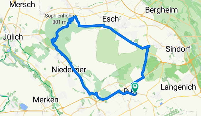
von Buir rund um den Tagebau
A cycling route starting in Merzenich, North Rhine-Westphalia, Germany.
Overview
About this route
- 2 h 48 min
- Duration
- 44.2 km
- Distance
- 261 m
- Ascent
- 260 m
- Descent
- 15.7 km/h
- Avg. speed
- 277 m
- Max. altitude
Route quality
Waytypes & surfaces along the route
Waytypes
Track
24.3 km
(55 %)
Quiet road
6.2 km
(14 %)
Surfaces
Paved
24.3 km
(55 %)
Unpaved
13.3 km
(30 %)
Asphalt
16.4 km
(37 %)
Paved (undefined)
8 km
(18 %)
Continue with Bikemap
Use, edit, or download this cycling route
You would like to ride von Buir rund um den Tagebau or customize it for your own trip? Here is what you can do with this Bikemap route:
Free features
- Save this route as favorite or in collections
- Copy & plan your own version of this route
- Sync your route with Garmin or Wahoo
Premium features
Free trial for 3 days, or one-time payment. More about Bikemap Premium.
- Navigate this route on iOS & Android
- Export a GPX / KML file of this route
- Create your custom printout (try it for free)
- Download this route for offline navigation
Discover more Premium features.
Get Bikemap PremiumFrom our community
Other popular routes starting in Merzenich
 Tour de Rur
- Distance
- 21.8 km
- Ascent
- 54 m
- Descent
- 54 m
- Location
- Merzenich, North Rhine-Westphalia, Germany
 Merzenich - Bitburg
- Distance
- 144.1 km
- Ascent
- 1,260 m
- Descent
- 1,039 m
- Location
- Merzenich, North Rhine-Westphalia, Germany
 Buir - Elsdorf, Physiotherapie
- Distance
- 12.7 km
- Ascent
- 31 m
- Descent
- 58 m
- Location
- Merzenich, North Rhine-Westphalia, Germany
 Tagebau Hambach
- Distance
- 59.1 km
- Ascent
- 86 m
- Descent
- 136 m
- Location
- Merzenich, North Rhine-Westphalia, Germany
 von Buir rund um den Tagebau
- Distance
- 44.2 km
- Ascent
- 261 m
- Descent
- 260 m
- Location
- Merzenich, North Rhine-Westphalia, Germany
 Bahnstraße 51, Kerpen nach Kentener Heide 15, Bergheim
- Distance
- 17.5 km
- Ascent
- 4 m
- Descent
- 3 m
- Location
- Merzenich, North Rhine-Westphalia, Germany
 Rhein-Braun-Route
- Distance
- 50.1 km
- Ascent
- 118 m
- Descent
- 120 m
- Location
- Merzenich, North Rhine-Westphalia, Germany
 Extensive Montag Track In Niederzier
- Distance
- 30.5 km
- Ascent
- 181 m
- Descent
- 181 m
- Location
- Merzenich, North Rhine-Westphalia, Germany
Open it in the app