Bia - Törökbálint - Érd - Sóskút - Bia
A cycling route starting in Biatorbágy, Pest megye, Hungary.
Overview
About this route
- 2 h 9 min
- Duration
- 36.8 km
- Distance
- 203 m
- Ascent
- 203 m
- Descent
- 17.1 km/h
- Avg. speed
- 191 m
- Avg. speed
Route quality
Waytypes & surfaces along the route
Waytypes
Busy road
17.2 km
(47 %)
Quiet road
8.3 km
(23 %)
Surfaces
Paved
27.1 km
(74 %)
Unpaved
4.6 km
(13 %)
Asphalt
26.8 km
(73 %)
Unpaved (undefined)
4.1 km
(11 %)
Continue with Bikemap
Use, edit, or download this cycling route
You would like to ride Bia - Törökbálint - Érd - Sóskút - Bia or customize it for your own trip? Here is what you can do with this Bikemap route:
Free features
- Save this route as favorite or in collections
- Copy & plan your own version of this route
- Sync your route with Garmin or Wahoo
Premium features
Free trial for 3 days, or one-time payment. More about Bikemap Premium.
- Navigate this route on iOS & Android
- Export a GPX / KML file of this route
- Create your custom printout (try it for free)
- Download this route for offline navigation
Discover more Premium features.
Get Bikemap PremiumFrom our community
Other popular routes starting in Biatorbágy
- Bia-Sóskút-Érd-MTB
- Distance
- 28.9 km
- Ascent
- 567 m
- Descent
- 567 m
- Location
- Biatorbágy, Pest megye, Hungary
- 2019.05.20. - Biatorbágy - Alcsút - Bicske
- Distance
- 35.8 km
- Ascent
- 294 m
- Descent
- 313 m
- Location
- Biatorbágy, Pest megye, Hungary
- Etyeki kör - From Biatorbágy
- Distance
- 51.2 km
- Ascent
- 410 m
- Descent
- 410 m
- Location
- Biatorbágy, Pest megye, Hungary
- Bartobagy-Budapest
- Distance
- 28.9 km
- Ascent
- 181 m
- Descent
- 192 m
- Location
- Biatorbágy, Pest megye, Hungary
- Biatorbágyi tekergés
- Distance
- 25.5 km
- Ascent
- 454 m
- Descent
- 454 m
- Location
- Biatorbágy, Pest megye, Hungary
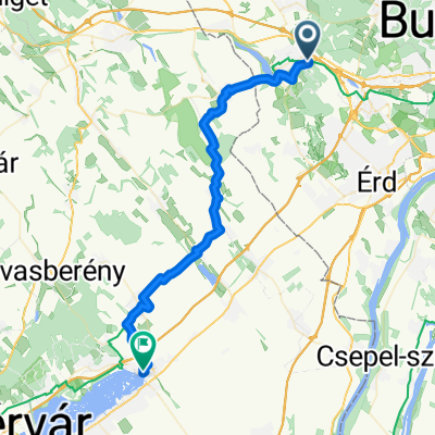
- Szabadság út, Biatorbágy - Őszibarack utca, Törökbálint
- Distance
- 35.5 km
- Ascent
- 545 m
- Descent
- 531 m
- Location
- Biatorbágy, Pest megye, Hungary
- Cycling from Biatorbágy to Velence
- Distance
- 76.2 km
- Ascent
- 652 m
- Descent
- 708 m
- Location
- Biatorbágy, Pest megye, Hungary
- Csajos edzés Tatára
- Distance
- 58.5 km
- Ascent
- 380 m
- Descent
- 429 m
- Location
- Biatorbágy, Pest megye, Hungary
Open it in the app