

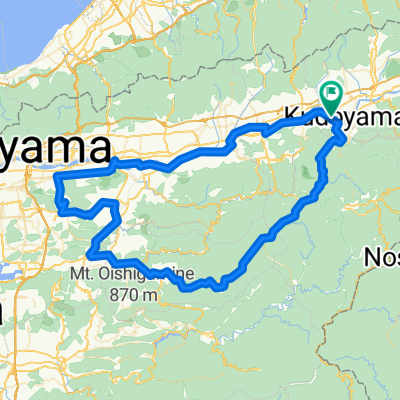
和歌山800-5(九度山起点左まわり)
A cycling route starting in Hashimoto, Wakayama, Japan.
Overview
About this route
- -:--
- Duration
- 120.5 km
- Distance
- 2,441 m
- Ascent
- 2,441 m
- Descent
- ---
- Avg. speed
- 862 m
- Max. altitude
Route quality
Waytypes & surfaces along the route
Waytypes
Cycleway
44.6 km
(37 %)
Quiet road
41 km
(34 %)
Surfaces
Paved
47 km
(39 %)
Paved (undefined)
42.2 km
(35 %)
Asphalt
4.8 km
(4 %)
Undefined
73.5 km
(61 %)
Route highlights
Points of interest along the route
Point of interest after 0 km
12道の駅 柿の郷くどやま
Point of interest after 9.8 km
11 丹生都比売神社
Point of interest after 9.8 km
10道の駅 くしがきの里
Point of interest after 10.9 km
9 道の駅 紀の川万葉の里
Point of interest after 27.9 km
7いわで御殿
Point of interest after 29.2 km
6道の駅 ねごろ歴史の丘
Point of interest after 36.2 km
1 太平洋岸自転車道ゴール和歌山s市加太141−2
Point of interest after 36.2 km
2市民スポーツ広場
Point of interest after 39.2 km
3和歌浦漁港 おっとっと広場
Point of interest after 40.3 km
4 道の駅 四季の郷公園
Point of interest after 41.4 km
5うるわし館 紀州漆器伝統産業会館
Point of interest after 41.4 km
20 浜のうたせ 駐車場
Point of interest after 49.6 km
8 しおん
Point of interest after 55.9 km
山3 千葉山
Point of interest after 55.9 km
23 平佐館
Point of interest after 55.9 km
24 温泉館海の里みちしおの湯
Point of interest after 55.9 km
22 広川町立ふれあい館
Point of interest after 55.9 km
25 煙樹ヶ浜堤防大壁画
Point of interest after 55.9 km
21 湯浅美味いもん蔵
Point of interest after 56 km
19 有田川町鉄道交流館
Point of interest after 56 km
26 日高港 新エネルギーパーク
Point of interest after 59.1 km
27 印南駅
Point of interest after 59.2 km
28 道の駅 サンピン中津
Point of interest after 63.6 km
山2 山の家おいし
Point of interest after 68.8 km
29道のほっとステーションみやまの里
Point of interest after 68.8 km
30 奥真妻活々倶楽部
Point of interest after 68.8 km
40 ホテルシーモア(バス)
Point of interest after 68.8 km
35 植芝盛平記念館 The Ueshiba Morihei Memorial Museum
Point of interest after 68.8 km
31紀州路みなべ
Point of interest after 71.1 km
16 丹生の都 美里の湯 かじか荘
Point of interest after 73.3 km
33 道の駅 水の郷日高川 龍游
Point of interest after 73.3 km
41 道の駅 志原海岸
Point of interest after 73.3 km
18 あらぎ島
Point of interest after 73.3 km
42 えびね温泉
Point of interest after 73.3 km
34 道の駅 紀州備長炭記念公園
Point of interest after 73.3 km
39 JR朝来駅
Point of interest after 74 km
38 熊野古道館
Point of interest after 74 km
43 道の駅 すさみ
Point of interest after 74.3 km
48 道の駅 虫喰岩
Point of interest after 74.3 km
37 道の駅 熊野古道中辺路
Point of interest after 74.3 km
44 佐本渓谷(佐本公衆トイレ)
Point of interest after 74.3 km
32 道の駅 龍神
Point of interest after 74.3 km
47 道の駅 一枚岩
Point of interest after 74.3 km
45 潮岬観光タワー
Point of interest after 74.3 km
46 トルコ記念館
Point of interest after 77.3 km
山4 道の駅 ごまさんスカイタワー
Point of interest after 82.4 km
17 はなぞの温泉 花圃(かほ)の里
Point of interest after 82.9 km
15 たまゆらの里
Point of interest after 97.6 km
50 那智の滝
Point of interest after 97.6 km
36 世界遺産熊野本宮館
Point of interest after 97.6 km
51 円満地公園
Point of interest after 97.6 km
山5 妙法山 阿弥陀寺
Point of interest after 97.6 km
54 小和瀬の渡し場跡
Point of interest after 97.6 km
山1 高野山観光情報センター
Point of interest after 97.8 km
49 太地町立くじらの博物館
Point of interest after 97.8 km
52 熊野速玉大社
Point of interest after 97.8 km
53 かあちゃんの店
Point of interest after 98.6 km
55 おくとろ温泉 やまのやど
Point of interest after 113.7 km
13くにぎ広場
Point of interest after 114.9 km
14 JR隅田駅
Continue with Bikemap
Use, edit, or download this cycling route
You would like to ride 和歌山800-5(九度山起点左まわり) or customize it for your own trip? Here is what you can do with this Bikemap route:
Free features
- Save this route as favorite or in collections
- Copy & plan your own version of this route
- Split it into stages to create a multi-day tour
- Sync your route with Garmin or Wahoo
Premium features
Free trial for 3 days, or one-time payment. More about Bikemap Premium.
- Navigate this route on iOS & Android
- Export a GPX / KML file of this route
- Create your custom printout (try it for free)
- Download this route for offline navigation
Discover more Premium features.
Get Bikemap PremiumFrom our community
Other popular routes starting in Hashimoto
 和歌山800-5(九度山起点左まわり)
- Distance
- 120.5 km
- Ascent
- 2,441 m
- Descent
- 2,441 m
- Location
- Hashimoto, Wakayama, Japan
 Slow ride in Koya-Cho, Ito-Gun
- Distance
- 21.2 km
- Ascent
- 2,999 m
- Descent
- 2,472 m
- Location
- Hashimoto, Wakayama, Japan
 和歌山800(ポイントあり)
- Distance
- 186.5 km
- Ascent
- 6,009 m
- Descent
- 5,257 m
- Location
- Hashimoto, Wakayama, Japan
 Kudoyama-Koyasan
- Distance
- 12.5 km
- Ascent
- 788 m
- Descent
- 119 m
- Location
- Hashimoto, Wakayama, Japan
 otani - gojo - hongu - owase - ise
- Distance
- 315.3 km
- Ascent
- 2,474 m
- Descent
- 2,523 m
- Location
- Hashimoto, Wakayama, Japan
 和歌山800-5(九度山起点)
- Distance
- 120.1 km
- Ascent
- 2,472 m
- Descent
- 2,471 m
- Location
- Hashimoto, Wakayama, Japan
 和歌山800(九度山起点)
- Distance
- 110.3 km
- Ascent
- 3,017 m
- Descent
- 3,017 m
- Location
- Hashimoto, Wakayama, Japan
 和歌山800-5(sc九度山起点左まわり)
- Distance
- 103.1 km
- Ascent
- 1,953 m
- Descent
- 1,953 m
- Location
- Hashimoto, Wakayama, Japan
Open it in the app