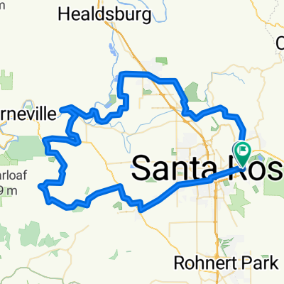
Bennett Valley-Lawndale-Oakmont-Santa Rosa
A cycling route starting in Santa Rosa, California, United States of America.
Overview
About this route
- 2 h 14 min
- Duration
- 44.3 km
- Distance
- 468 m
- Ascent
- 468 m
- Descent
- 19.8 km/h
- Avg. speed
- ---
- Avg. speed
Route photos
Route quality
Waytypes & surfaces along the route
Waytypes
Quiet road
17.5 km
(39 %)
Road
16.1 km
(36 %)
Surfaces
Paved
2.4 km
(6 %)
Asphalt
1.8 km
(4 %)
Concrete
0.7 km
(1 %)
Undefined
41.9 km
(94 %)
Continue with Bikemap
Use, edit, or download this cycling route
You would like to ride Bennett Valley-Lawndale-Oakmont-Santa Rosa or customize it for your own trip? Here is what you can do with this Bikemap route:
Free features
- Save this route as favorite or in collections
- Copy & plan your own version of this route
- Sync your route with Garmin or Wahoo
Premium features
Free trial for 3 days, or one-time payment. More about Bikemap Premium.
- Navigate this route on iOS & Android
- Export a GPX / KML file of this route
- Create your custom printout (try it for free)
- Download this route for offline navigation
Discover more Premium features.
Get Bikemap PremiumFrom our community
Other popular routes starting in Santa Rosa
- Sonoma Halloween 110K
- Distance
- 113 km
- Ascent
- 863 m
- Descent
- 863 m
- Location
- Santa Rosa, California, United States of America
- Los Alamos
- Distance
- 36.7 km
- Ascent
- 673 m
- Descent
- 638 m
- Location
- Santa Rosa, California, United States of America
- Bennett Valley-Lawndale-Oakmont-Santa Rosa
- Distance
- 44.3 km
- Ascent
- 468 m
- Descent
- 468 m
- Location
- Santa Rosa, California, United States of America
- Brief bike tour through Santa Rosa
- Distance
- 5.6 km
- Ascent
- 9 m
- Descent
- 31 m
- Location
- Santa Rosa, California, United States of America
- Glen Ellen Ride
- Distance
- 25.5 km
- Ascent
- 222 m
- Descent
- 222 m
- Location
- Santa Rosa, California, United States of America
- Pine Flat Rd.
- Distance
- 103 km
- Ascent
- 2,248 m
- Descent
- 2,239 m
- Location
- Santa Rosa, California, United States of America
- Santa Rosa Loop
- Distance
- 52.2 km
- Ascent
- 533 m
- Descent
- 536 m
- Location
- Santa Rosa, California, United States of America
- Super Fountaingrove
- Distance
- 20.7 km
- Ascent
- 518 m
- Descent
- 518 m
- Location
- Santa Rosa, California, United States of America
Open it in the app