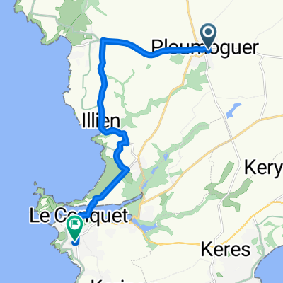
Ploumoguer - Brest
A cycling route starting in Ploumoguer, Brittany Region, France.
Overview
About this route
- -:--
- Duration
- 24.4 km
- Distance
- 186 m
- Ascent
- 236 m
- Descent
- ---
- Avg. speed
- 100 m
- Max. altitude
Route quality
Waytypes & surfaces along the route
Waytypes
Road
14.9 km
(61 %)
Cycleway
4.9 km
(20 %)
Surfaces
Paved
18.6 km
(76 %)
Asphalt
18.3 km
(75 %)
Wood
0.2 km
(1 %)
Undefined
5.9 km
(24 %)
Continue with Bikemap
Use, edit, or download this cycling route
You would like to ride Ploumoguer - Brest or customize it for your own trip? Here is what you can do with this Bikemap route:
Free features
- Save this route as favorite or in collections
- Copy & plan your own version of this route
- Sync your route with Garmin or Wahoo
Premium features
Free trial for 3 days, or one-time payment. More about Bikemap Premium.
- Navigate this route on iOS & Android
- Export a GPX / KML file of this route
- Create your custom printout (try it for free)
- Download this route for offline navigation
Discover more Premium features.
Get Bikemap PremiumFrom our community
Other popular routes starting in Ploumoguer
- Itinéraire vers 216 Kerescar, Ploumoguer
- Distance
- 6.4 km
- Ascent
- 97 m
- Descent
- 64 m
- Location
- Ploumoguer, Brittany Region, France
- Ploumoguer - Brest
- Distance
- 24.4 km
- Ascent
- 186 m
- Descent
- 236 m
- Location
- Ploumoguer, Brittany Region, France
- Recovered Route
- Distance
- 5 km
- Ascent
- 25 m
- Descent
- 45 m
- Location
- Ploumoguer, Brittany Region, France
- Blancs Sablons for Mari
- Distance
- 8.4 km
- Ascent
- 45 m
- Descent
- 103 m
- Location
- Ploumoguer, Brittany Region, France
- De 85–95 Rue de Kerhornou, Ploumoguer à 6 Boulevard de la Mer, Plougonvelin
- Distance
- 11.8 km
- Ascent
- 178 m
- Descent
- 226 m
- Location
- Ploumoguer, Brittany Region, France
- Rue du Bilou, Le Conquet to Place du Général de Gaulle, Ploumoguer
- Distance
- 11.1 km
- Ascent
- 76 m
- Descent
- 133 m
- Location
- Ploumoguer, Brittany Region, France
- Ploumoguer to Rue du Bilou, Le Conquet
- Distance
- 12.4 km
- Ascent
- 79 m
- Descent
- 136 m
- Location
- Ploumoguer, Brittany Region, France
- Ploumogeur to Mouchotte
- Distance
- 13 km
- Ascent
- 186 m
- Descent
- 190 m
- Location
- Ploumoguer, Brittany Region, France
Open it in the app