

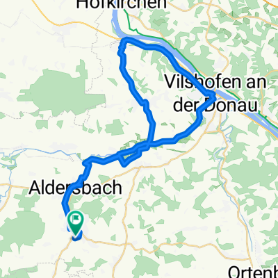
Around Aidenbach
A cycling route starting in Aidenbach, Bavaria, Germany.
Overview
About this route
- 1 h 36 min
- Duration
- 35.4 km
- Distance
- 416 m
- Ascent
- 415 m
- Descent
- 22.1 km/h
- Avg. speed
- ---
- Max. altitude

Route photos


Route quality
Waytypes & surfaces along the route
Waytypes
Quiet road
13.8 km
(39 %)
Road
8.7 km
(24 %)
Surfaces
Paved
15.3 km
(43 %)
Unpaved
9.1 km
(26 %)
Asphalt
14.1 km
(40 %)
Gravel
6.3 km
(18 %)
Continue with Bikemap
Use, edit, or download this cycling route
You would like to ride Around Aidenbach or customize it for your own trip? Here is what you can do with this Bikemap route:
Free features
- Save this route as favorite or in collections
- Copy & plan your own version of this route
- Sync your route with Garmin or Wahoo
Premium features
Free trial for 3 days, or one-time payment. More about Bikemap Premium.
- Navigate this route on iOS & Android
- Export a GPX / KML file of this route
- Create your custom printout (try it for free)
- Download this route for offline navigation
Discover more Premium features.
Get Bikemap PremiumFrom our community
Other popular routes starting in Aidenbach
 Marktplatz 29, Aidenbach nach Michl-Natter-Straße 2, Vilshofen an der Donau
- Distance
- 9.1 km
- Ascent
- 278 m
- Descent
- 374 m
- Location
- Aidenbach, Bavaria, Germany
 Around Aidenbach
- Distance
- 35.4 km
- Ascent
- 416 m
- Descent
- 415 m
- Location
- Aidenbach, Bavaria, Germany
 Tittling-Aicha vorm Wald
- Distance
- 101.7 km
- Ascent
- 1,397 m
- Descent
- 1,399 m
- Location
- Aidenbach, Bavaria, Germany
 Einfache Fahrt in Vilshofen an der Donau
- Distance
- 11.2 km
- Ascent
- 64 m
- Descent
- 56 m
- Location
- Aidenbach, Bavaria, Germany
 Uttigkofen - Schwimmbach
- Distance
- 58.9 km
- Ascent
- 285 m
- Descent
- 220 m
- Location
- Aidenbach, Bavaria, Germany
 Birkenstraße, Aidenbach nach Birkenstraße, Aidenbach
- Distance
- 38.1 km
- Ascent
- 248 m
- Descent
- 245 m
- Location
- Aidenbach, Bavaria, Germany
 Schnelle Tour in
- Distance
- 4.6 km
- Ascent
- 77 m
- Descent
- 26 m
- Location
- Aidenbach, Bavaria, Germany
 Aidenbachtour 23km
- Distance
- 22.8 km
- Ascent
- 183 m
- Descent
- 183 m
- Location
- Aidenbach, Bavaria, Germany
Open it in the app