

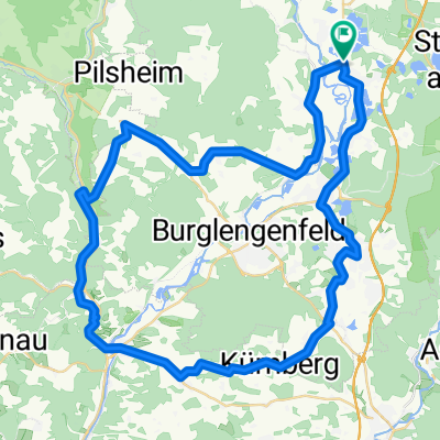
Nach Kallmünz - schnell und flach
A cycling route starting in Schwandorf in Bayern, Bavaria, Germany.
Overview
About this route
Diese Route gehört zu meinen Lieblingsrouten.
Anfangs- und Endpunkt ist der "Klardorfer Kreisel" an der B 15 am nördlichen Ortsende von Klardorf. Die Route ist auch für weniger Geübte geeignet, wenn man sie als Tagesausflug fährt. In diesem Fall empfiehlt sich die Mittagspause in Kallmünz, da dort eine große Auswahl an Gaststätten vorhanden ist. Auf dem Rückweg sollte man sich keineswegs das leckere Eis bei David in Teublitz entgehen lassen. Die Route kann auch in umgekehrter Richtung befahren werden, dann allerdings steigt die Strecke von Kallmünz bis Maxhütte-Haidhof zwar nicht stark, aber lästig.- -:--
- Duration
- 48.1 km
- Distance
- 163 m
- Ascent
- 164 m
- Descent
- ---
- Avg. speed
- ---
- Avg. speed

Route quality
Waytypes & surfaces along the route
Waytypes
Road
16.3 km
(34 %)
Busy road
12.9 km
(27 %)
Surfaces
Paved
30 km
(62 %)
Unpaved
0.7 km
(1 %)
Asphalt
29.9 km
(62 %)
Gravel
0.7 km
(1 %)
Continue with Bikemap
Use, edit, or download this cycling route
You would like to ride Nach Kallmünz - schnell und flach or customize it for your own trip? Here is what you can do with this Bikemap route:
Free features
- Save this route as favorite or in collections
- Copy & plan your own version of this route
- Sync your route with Garmin or Wahoo
Premium features
Free trial for 3 days, or one-time payment. More about Bikemap Premium.
- Navigate this route on iOS & Android
- Export a GPX / KML file of this route
- Create your custom printout (try it for free)
- Download this route for offline navigation
Discover more Premium features.
Get Bikemap PremiumFrom our community
Other popular routes starting in Schwandorf in Bayern
 Rund um Naabeck
- Distance
- 18.7 km
- Ascent
- 159 m
- Descent
- 159 m
- Location
- Schwandorf in Bayern, Bavaria, Germany
 Angerring 35, Schwandorf nach Angerring 34, Schwandorf
- Distance
- 17.4 km
- Ascent
- 199 m
- Descent
- 198 m
- Location
- Schwandorf in Bayern, Bavaria, Germany
 Kallmünz übers Vilstal
- Distance
- 57.9 km
- Ascent
- 340 m
- Descent
- 343 m
- Location
- Schwandorf in Bayern, Bavaria, Germany
 Saale 4 kurz: Schwandorf - Kotzenbach, Gasthaus Mois, 70,5km, 271hm
- Distance
- 70.8 km
- Ascent
- 230 m
- Descent
- 183 m
- Location
- Schwandorf in Bayern, Bavaria, Germany
 B2-4/Saale 4a kurz: Ettmannsdorf-West - Weiden, Am Tor, 57,4km, 170hm
- Distance
- 57.4 km
- Ascent
- 256 m
- Descent
- 240 m
- Location
- Schwandorf in Bayern, Bavaria, Germany
 Einfürungstour / Sa 30.06.2012
- Distance
- 31.9 km
- Ascent
- 230 m
- Descent
- 230 m
- Location
- Schwandorf in Bayern, Bavaria, Germany
 Oberpfälzisch-Fränkische Jakobsweg
- Distance
- 123.1 km
- Ascent
- 745 m
- Descent
- 801 m
- Location
- Schwandorf in Bayern, Bavaria, Germany
 Richter Berg Ka1, 1,5km, 45HM
- Distance
- 3.8 km
- Ascent
- 58 m
- Descent
- 55 m
- Location
- Schwandorf in Bayern, Bavaria, Germany
Open it in the app