

Bikeführer "Sontraer Runde"
A cycling route starting in Eschwege, Hesse, Germany.
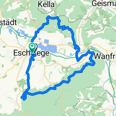
Overview
About this route
medium-difficulty road cycling tour
Route description:
Eschwege-Niederhone-Reichensachsen-Oetmannshausen-Bischhausen-Waldkappel-Friemen-Burghofe-Schemmern-Gehau-Eltmannsee-Königswald-Rockensüß-Cornberg-Boxerode-Dens-Möchhosbach-Hornel-Sontra-Wichmannshausen-Datterode-Röhrda-Langenhain-Eschwege
For more: www.Bikeführer-Werra-Meissner.de
Ideal for mountain biking and road cycling holidays in the Werra Valley
- -:--
- Duration
- 81.4 km
- Distance
- 773 m
- Ascent
- 742 m
- Descent
- ---
- Avg. speed
- 423 m
- Max. altitude

Route quality
Waytypes & surfaces along the route
Waytypes
Track
22 km
(27 %)
Road
21.2 km
(26 %)
Surfaces
Paved
46.4 km
(57 %)
Asphalt
35.8 km
(44 %)
Paved (undefined)
7.3 km
(9 %)
Continue with Bikemap
Use, edit, or download this cycling route
You would like to ride Bikeführer "Sontraer Runde" or customize it for your own trip? Here is what you can do with this Bikemap route:
Free features
- Save this route as favorite or in collections
- Copy & plan your own version of this route
- Split it into stages to create a multi-day tour
- Sync your route with Garmin or Wahoo
Premium features
Free trial for 3 days, or one-time payment. More about Bikemap Premium.
- Navigate this route on iOS & Android
- Export a GPX / KML file of this route
- Create your custom printout (try it for free)
- Download this route for offline navigation
Discover more Premium features.
Get Bikemap PremiumFrom our community
Other popular routes starting in Eschwege
 Bikeführer MTB "Zum Wichtelbrunnen"
- Distance
- 28.2 km
- Ascent
- 563 m
- Descent
- 557 m
- Location
- Eschwege, Hesse, Germany
 Bikeführer MTB "Vom Lotzenkopf zum Meinhard"
- Distance
- 33.6 km
- Ascent
- 645 m
- Descent
- 643 m
- Location
- Eschwege, Hesse, Germany
 Werra-Man Runde
- Distance
- 22 km
- Ascent
- 218 m
- Descent
- 203 m
- Location
- Eschwege, Hesse, Germany
 Bikeführer "Sontraer Runde"
- Distance
- 81.4 km
- Ascent
- 773 m
- Descent
- 742 m
- Location
- Eschwege, Hesse, Germany
 Bikeführer "Über Hausen auf den Hohen Meißner"
- Distance
- 78.8 km
- Ascent
- 927 m
- Descent
- 930 m
- Location
- Eschwege, Hesse, Germany
 Bikeführer "Zum Eichsfelder Dom"
- Distance
- 58.9 km
- Ascent
- 685 m
- Descent
- 695 m
- Location
- Eschwege, Hesse, Germany
 13.07.26 Eschwege-Mengershausen
- Distance
- 61.9 km
- Ascent
- 329 m
- Descent
- 312 m
- Location
- Eschwege, Hesse, Germany
 Bikeführer "Durchs Riedbachtal ins Meißnervorland"
- Distance
- 64 km
- Ascent
- 609 m
- Descent
- 572 m
- Location
- Eschwege, Hesse, Germany
Open it in the app