
déi gréng - randonnée ennersauer CLONED FROM ROUTE 129120
A cycling route starting in Langsur, Rhineland-Palatinate, Germany.
Overview
About this route
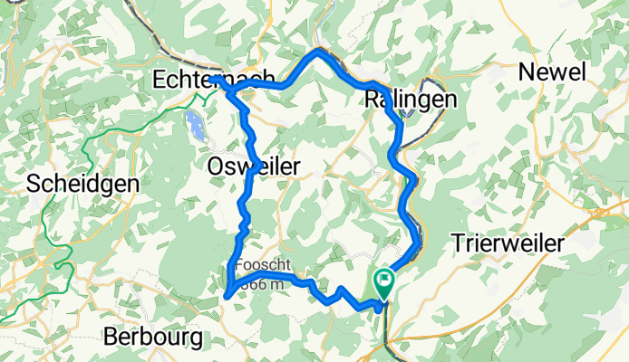
Sunday, May 24: TOUR 4 – 'Ennersauer' (10am-4pm) Mompach – Herborn – Osweiler – Echternach – Steinheim – Rosport (lunch break at the restaurant) – Hinkel – Born – Moersdorf – Givenich – Mompach
- -:--
- Duration
- 32.1 km
- Distance
- 405 m
- Ascent
- 405 m
- Descent
- ---
- Avg. speed
- ---
- Max. altitude
Route quality
Waytypes & surfaces along the route
Waytypes
Track
2.6 km
(8 %)
Quiet road
1.3 km
(4 %)
Surfaces
Paved
30.8 km
(96 %)
Unpaved
0.3 km
(1 %)
Asphalt
28.9 km
(90 %)
Paved (undefined)
1.9 km
(6 %)
Continue with Bikemap
Use, edit, or download this cycling route
You would like to ride déi gréng - randonnée ennersauer CLONED FROM ROUTE 129120 or customize it for your own trip? Here is what you can do with this Bikemap route:
Free features
- Save this route as favorite or in collections
- Copy & plan your own version of this route
- Sync your route with Garmin or Wahoo
Premium features
Free trial for 3 days, or one-time payment. More about Bikemap Premium.
- Navigate this route on iOS & Android
- Export a GPX / KML file of this route
- Create your custom printout (try it for free)
- Download this route for offline navigation
Discover more Premium features.
Get Bikemap PremiumFrom our community
Other popular routes starting in Langsur
 Sauertal-Tour
- Distance
- 97.5 km
- Ascent
- 278 m
- Descent
- 282 m
- Location
- Langsur, Rhineland-Palatinate, Germany
 déi gréng - randonnée ennersauer
- Distance
- 32 km
- Ascent
- 484 m
- Descent
- 477 m
- Location
- Langsur, Rhineland-Palatinate, Germany
 B/D Mesenich - Bitburg
- Distance
- 37.5 km
- Ascent
- 462 m
- Descent
- 287 m
- Location
- Langsur, Rhineland-Palatinate, Germany
 Etappe 4
- Distance
- 107 km
- Ascent
- 399 m
- Descent
- 249 m
- Location
- Langsur, Rhineland-Palatinate, Germany
 déi gréng - randonnée ennersauer CLONED FROM ROUTE 129120
- Distance
- 32.1 km
- Ascent
- 405 m
- Descent
- 405 m
- Location
- Langsur, Rhineland-Palatinate, Germany
 Osweiler 1
- Distance
- 28 km
- Ascent
- 472 m
- Descent
- 469 m
- Location
- Langsur, Rhineland-Palatinate, Germany
 dag 4. Mesenich - Metz >100km
- Distance
- 104.3 km
- Ascent
- 91 m
- Descent
- 53 m
- Location
- Langsur, Rhineland-Palatinate, Germany
 wasserbillig-Senningerberg-wasserbillig
- Distance
- 76.2 km
- Ascent
- 402 m
- Descent
- 402 m
- Location
- Langsur, Rhineland-Palatinate, Germany
Open it in the app