

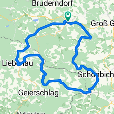
Freiwald-Strecke lang
A cycling route starting in Langschlag, Lower Austria, Austria.
Overview
About this route
Langschlag - Bruderndorf - Binderberg - Hirschau - Liebenau - Bruderndorferwald - Siebenhf6f - Langschlag
- -:--
- Duration
- 38.7 km
- Distance
- 844 m
- Ascent
- 843 m
- Descent
- ---
- Avg. speed
- 984 m
- Max. altitude

Route quality
Waytypes & surfaces along the route
Waytypes
Track
20.5 km
(53 %)
Quiet road
13.9 km
(36 %)
Surfaces
Paved
5.8 km
(15 %)
Unpaved
19.4 km
(50 %)
Gravel
10.1 km
(26 %)
Unpaved (undefined)
6.2 km
(16 %)
Continue with Bikemap
Use, edit, or download this cycling route
You would like to ride Freiwald-Strecke lang or customize it for your own trip? Here is what you can do with this Bikemap route:
Free features
- Save this route as favorite or in collections
- Copy & plan your own version of this route
- Sync your route with Garmin or Wahoo
Premium features
Free trial for 3 days, or one-time payment. More about Bikemap Premium.
- Navigate this route on iOS & Android
- Export a GPX / KML file of this route
- Create your custom printout (try it for free)
- Download this route for offline navigation
Discover more Premium features.
Get Bikemap PremiumFrom our community
Other popular routes starting in Langschlag
 Gravel Austria, Etappe Niederösterreich
- Distance
- 522.8 km
- Ascent
- 7,970 m
- Descent
- 8,788 m
- Location
- Langschlag, Lower Austria, Austria
 Tannermoor
- Distance
- 38.7 km
- Ascent
- 757 m
- Descent
- 759 m
- Location
- Langschlag, Lower Austria, Austria
 Klein Wetzles Runde
- Distance
- 33.1 km
- Ascent
- 480 m
- Descent
- 480 m
- Location
- Langschlag, Lower Austria, Austria
 Nordwaldtour
- Distance
- 38.2 km
- Ascent
- 197 m
- Descent
- 625 m
- Location
- Langschlag, Lower Austria, Austria
 Eichelberg - Strecke
- Distance
- 9.3 km
- Ascent
- 217 m
- Descent
- 220 m
- Location
- Langschlag, Lower Austria, Austria
 Naturparkwanderweg(10000 Schritte)
- Distance
- 7.1 km
- Ascent
- 178 m
- Descent
- 178 m
- Location
- Langschlag, Lower Austria, Austria
 2 Ländertour
- Distance
- 58.7 km
- Ascent
- 1,027 m
- Descent
- 1,022 m
- Location
- Langschlag, Lower Austria, Austria
 Am Berg 170, Langschlag nach Am Berg 170, Langschlag
- Distance
- 6.8 km
- Ascent
- 126 m
- Descent
- 174 m
- Location
- Langschlag, Lower Austria, Austria
Open it in the app