

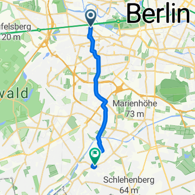
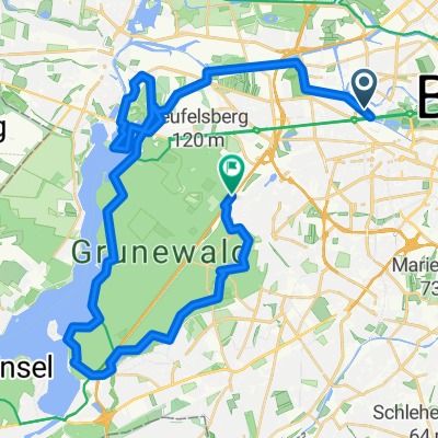
Europa-Center-Neukölln
A cycling route starting in Hansaviertel, State of Berlin, Germany.
Overview
About this route
Very nice route, almost solely through small streets, parks, and green spaces
- -:--
- Duration
- 11.5 km
- Distance
- 61 m
- Ascent
- 43 m
- Descent
- ---
- Avg. speed
- 57 m
- Max. altitude

Route quality
Waytypes & surfaces along the route
Waytypes
Pedestrian area
4.8 km
(42 %)
Quiet road
3 km
(26 %)
Surfaces
Paved
9.8 km
(85 %)
Asphalt
9.6 km
(83 %)
Paved (undefined)
0.1 km
(1 %)
Continue with Bikemap
Use, edit, or download this cycling route
You would like to ride Europa-Center-Neukölln or customize it for your own trip? Here is what you can do with this Bikemap route:
Free features
- Save this route as favorite or in collections
- Copy & plan your own version of this route
- Sync your route with Garmin or Wahoo
Premium features
Free trial for 3 days, or one-time payment. More about Bikemap Premium.
- Navigate this route on iOS & Android
- Export a GPX / KML file of this route
- Create your custom printout (try it for free)
- Download this route for offline navigation
Discover more Premium features.
Get Bikemap PremiumFrom our community
Other popular routes starting in Hansaviertel
 Berlin-Schiffsanleger
- Distance
- 10.9 km
- Ascent
- 66 m
- Descent
- 68 m
- Location
- Hansaviertel, State of Berlin, Germany
 Lichterfelde-Ost-RenaissanceTheater
- Distance
- 10.9 km
- Ascent
- 53 m
- Descent
- 51 m
- Location
- Hansaviertel, State of Berlin, Germany
 Berlijn Dag 2 Etappe 4 EV
- Distance
- 5.2 km
- Ascent
- 60 m
- Descent
- 70 m
- Location
- Hansaviertel, State of Berlin, Germany
 Berlijn Dag 2 Etappe 4
- Distance
- 5.3 km
- Ascent
- 36 m
- Descent
- 50 m
- Location
- Hansaviertel, State of Berlin, Germany
 Ku'damm - Havel Chaussee - P'dam - Spandau - Tegel
- Distance
- 81 km
- Ascent
- 250 m
- Descent
- 248 m
- Location
- Hansaviertel, State of Berlin, Germany
 Einsteinufer-Murellenschlucht-Pichelswerder-Grundewald
- Distance
- 41.8 km
- Ascent
- 344 m
- Descent
- 331 m
- Location
- Hansaviertel, State of Berlin, Germany
 B02_Berliner Mauertour
- Distance
- 35.2 km
- Ascent
- 68 m
- Descent
- 68 m
- Location
- Hansaviertel, State of Berlin, Germany
 Budapester Straße, Berlin nach Unter den Linden, Berlin
- Distance
- 8.9 km
- Ascent
- 70 m
- Descent
- 115 m
- Location
- Hansaviertel, State of Berlin, Germany
Open it in the app