

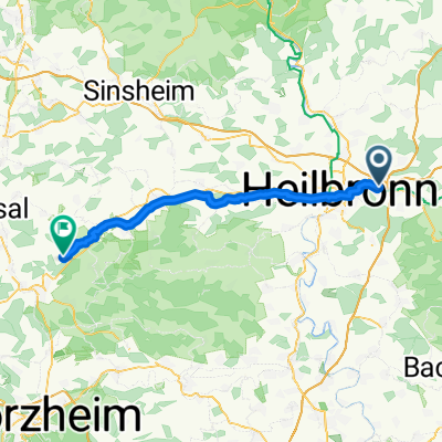
Weinsberg - Lauffen am Neckar
A cycling route starting in Weinsberg, Baden-Wurttemberg, Germany.
Overview
About this route
- -:--
- Duration
- 42.7 km
- Distance
- 334 m
- Ascent
- 334 m
- Descent
- ---
- Avg. speed
- 315 m
- Max. altitude

Route photos


Route quality
Waytypes & surfaces along the route
Waytypes
Track
18.3 km
(43 %)
Path
10.2 km
(24 %)
Surfaces
Paved
39.3 km
(92 %)
Unpaved
0.4 km
(1 %)
Asphalt
38 km
(89 %)
Paved (undefined)
0.9 km
(2 %)
Continue with Bikemap
Use, edit, or download this cycling route
You would like to ride Weinsberg - Lauffen am Neckar or customize it for your own trip? Here is what you can do with this Bikemap route:
Free features
- Save this route as favorite or in collections
- Copy & plan your own version of this route
- Sync your route with Garmin or Wahoo
Premium features
Free trial for 3 days, or one-time payment. More about Bikemap Premium.
- Navigate this route on iOS & Android
- Export a GPX / KML file of this route
- Create your custom printout (try it for free)
- Download this route for offline navigation
Discover more Premium features.
Get Bikemap PremiumFrom our community
Other popular routes starting in Weinsberg
 Öhringen - Gondelsheim
- Distance
- 48.8 km
- Ascent
- 448 m
- Descent
- 433 m
- Location
- Weinsberg, Baden-Wurttemberg, Germany
 bike tour through Weinsberg
- Distance
- 29.6 km
- Ascent
- 197 m
- Descent
- 198 m
- Location
- Weinsberg, Baden-Wurttemberg, Germany
 Weinsberg Schillingsfürst
- Distance
- 161.4 km
- Ascent
- 1,476 m
- Descent
- 1,268 m
- Location
- Weinsberg, Baden-Wurttemberg, Germany
 Weinberg-Löwennsteiner Berge - Waldheide
- Distance
- 30.4 km
- Ascent
- 652 m
- Descent
- 542 m
- Location
- Weinsberg, Baden-Wurttemberg, Germany
 Training Weinberg - Neuenstadt - Neckarsulm
- Distance
- 27.5 km
- Ascent
- 382 m
- Descent
- 384 m
- Location
- Weinsberg, Baden-Wurttemberg, Germany
 WT1 Wiesen, Wein und treue Weiber
- Distance
- 13.4 km
- Ascent
- 283 m
- Descent
- 283 m
- Location
- Weinsberg, Baden-Wurttemberg, Germany
 sehr schöne MTB Tour
- Distance
- 12.2 km
- Ascent
- 204 m
- Descent
- 204 m
- Location
- Weinsberg, Baden-Wurttemberg, Germany
 Weinsberg - Burg Guttenberg
- Distance
- 59.6 km
- Ascent
- 326 m
- Descent
- 326 m
- Location
- Weinsberg, Baden-Wurttemberg, Germany
Open it in the app