
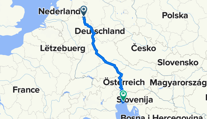
Enger-Lignano Sabbiadoro
A cycling route starting in Enger, North Rhine-Westphalia, Germany.
Overview
About this route
Ich bin diese Route 1995 gefahren und werde sie noch einmal wiederholen, allerdings jetzt mit E-Bike :-))
- -:--
- Duration
- 1,181.8 km
- Distance
- 13,410 m
- Ascent
- 13,504 m
- Descent
- ---
- Avg. speed
- 2,501 m
- Max. altitude
Route photos

Continue with Bikemap
Use, edit, or download this cycling route
You would like to ride Enger-Lignano Sabbiadoro or customize it for your own trip? Here is what you can do with this Bikemap route:
Free features
- Save this route as favorite or in collections
- Copy & plan your own version of this route
- Split it into stages to create a multi-day tour
- Sync your route with Garmin or Wahoo
Premium features
Free trial for 3 days, or one-time payment. More about Bikemap Premium.
- Navigate this route on iOS & Android
- Export a GPX / KML file of this route
- Create your custom printout (try it for free)
- Download this route for offline navigation
Discover more Premium features.
Get Bikemap PremiumFrom our community
Other popular routes starting in Enger
 Enger Borgholzhausen Enger
- Distance
- 51.2 km
- Ascent
- 331 m
- Descent
- 310 m
- Location
- Enger, North Rhine-Westphalia, Germany
 Kleine Waldrunde in Laar
- Distance
- 3.2 km
- Ascent
- 42 m
- Descent
- 42 m
- Location
- Enger, North Rhine-Westphalia, Germany
 4 - Gipfeltour
- Distance
- 69.1 km
- Ascent
- 615 m
- Descent
- 607 m
- Location
- Enger, North Rhine-Westphalia, Germany
 Enger - Sundern - Lippingh. - Oetingh. - Besenkamp - Dreyen - Päschenheide - Enger
- Distance
- 30.8 km
- Ascent
- 175 m
- Descent
- 186 m
- Location
- Enger, North Rhine-Westphalia, Germany
 Kleine Runde Richtung Schröttinghausen
- Distance
- 19.4 km
- Ascent
- 169 m
- Descent
- 169 m
- Location
- Enger, North Rhine-Westphalia, Germany
 Enger-Lignano Sabbiadoro
- Distance
- 1,181.8 km
- Ascent
- 13,410 m
- Descent
- 13,504 m
- Location
- Enger, North Rhine-Westphalia, Germany
 Enger Holzhausen Wiehengeb Bünde Enger
- Distance
- 47 km
- Ascent
- 405 m
- Descent
- 409 m
- Location
- Enger, North Rhine-Westphalia, Germany
 Abendrunde
- Distance
- 12.8 km
- Ascent
- 69 m
- Descent
- 68 m
- Location
- Enger, North Rhine-Westphalia, Germany
Open it in the app