
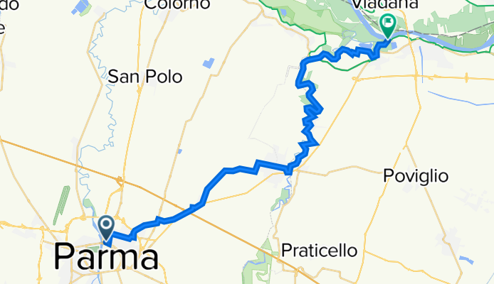
b) 15 PR Ciclovia Parma - Brescello; from Parma to Brescello (river Po)
A cycling route starting in Parma, Emilia-Romagna, Italy.
Overview
About this route
Percorso sovra-provinciale prevalentemente in sede protetta. La prima parte unisce la città di Parma con Sorbolo sfruttando un recupero di ex ferrovia e una nuova (2021) pista ciclabile a lato strada. Si attraversa l'abitato di Sorbolo poi il fiume Enza su spalliera ciclabile del ponte della ex statale 62 e si segue il fiume su argine ciclabile fino all'abitato di Brscello. L'ultima parte del percorso è posta su argine non ancora stabilizzato. E' possibile altresì arrivare in bici in sicurezza fino alla foce dell'Enza nel fiume Po. Questo ultimo tratto giace anche sulla ciclovie del Po in sponda destra.
Eng
Inter- provincial route mainly in a protected path. The first part combines the city of Parma with Sorbolo by exploiting an ex-railroad track and a new (2021) bike path near the main road. It crosses then the Enza river on the cycle side of the bridge of the former national road 62 and follows the river on cycle embankment until the village of Brescello. The last part of the route is placed on embankment not yet stabilized. It is also possible to arrive by bike safely until the mouth of the Enza river in the Po river. This last stretch also lies on the river Po cycle route on the right bank.
- -:--
- Duration
- 30 km
- Distance
- 13 m
- Ascent
- 45 m
- Descent
- ---
- Avg. speed
- 57 m
- Max. altitude

Route photos
 15 PR Ciclovia Parma - Brescello; from Parma to Brescello (river Po)\"")
 15 PR Ciclovia Parma - Brescello; from Parma to Brescello (river Po)\"")
 15 PR Ciclovia Parma - Brescello; from Parma to Brescello (river Po)\"")
 15 PR Ciclovia Parma - Brescello; from Parma to Brescello (river Po)\"")
Route quality
Waytypes & surfaces along the route
Waytypes
Track
12.3 km
(41 %)
Cycleway
8.7 km
(29 %)
Surfaces
Paved
17.1 km
(57 %)
Unpaved
2.4 km
(8 %)
Asphalt
13.8 km
(46 %)
Paved (undefined)
3.3 km
(11 %)
Continue with Bikemap
Use, edit, or download this cycling route
You would like to ride b) 15 PR Ciclovia Parma - Brescello; from Parma to Brescello (river Po) or customize it for your own trip? Here is what you can do with this Bikemap route:
Free features
- Save this route as favorite or in collections
- Copy & plan your own version of this route
- Sync your route with Garmin or Wahoo
Premium features
Free trial for 3 days, or one-time payment. More about Bikemap Premium.
- Navigate this route on iOS & Android
- Export a GPX / KML file of this route
- Create your custom printout (try it for free)
- Download this route for offline navigation
Discover more Premium features.
Get Bikemap PremiumFrom our community
Other popular routes starting in Parma
 giro Torrechiara
- Distance
- 55.1 km
- Ascent
- 390 m
- Descent
- 390 m
- Location
- Parma, Emilia-Romagna, Italy
 1 Oct Parma to Reggio Emilia via Montechiarugolo -Montecchio
- Distance
- 46.3 km
- Ascent
- 164 m
- Descent
- 158 m
- Location
- Parma, Emilia-Romagna, Italy
 ieri sera
- Distance
- 16.6 km
- Ascent
- 30 m
- Descent
- 30 m
- Location
- Parma, Emilia-Romagna, Italy
 b) 01 PR Anello dei castelli sud tra Baganza e Parma: Sala Baganza Felino Torrechiara
- Distance
- 53.6 km
- Ascent
- 429 m
- Descent
- 428 m
- Location
- Parma, Emilia-Romagna, Italy
 Argini parmensi
- Distance
- 64.4 km
- Ascent
- 58 m
- Descent
- 61 m
- Location
- Parma, Emilia-Romagna, Italy
 B4 Parma- Montechiarugolo -Montecchio - Rivalta Re
- Distance
- 56.5 km
- Ascent
- 246 m
- Descent
- 210 m
- Location
- Parma, Emilia-Romagna, Italy
 Parma-Traversetolo-Langhirano-Felino-Parma
- Distance
- 60.5 km
- Ascent
- 408 m
- Descent
- 408 m
- Location
- Parma, Emilia-Romagna, Italy
 b) 04 PR Anello Parma - Colorno e ritorno 2 su asfalto
- Distance
- 36.2 km
- Ascent
- 93 m
- Descent
- 91 m
- Location
- Parma, Emilia-Romagna, Italy
Open it in the app