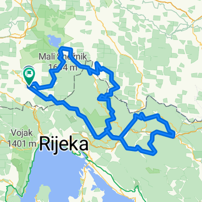
Z biči po Čiči 2
A cycling route starting in Ilirska Bistrica, Ilirska Bistrica, Slovenia.
Overview
About this route
- -:--
- Duration
- 45.1 km
- Distance
- 645 m
- Ascent
- 644 m
- Descent
- ---
- Avg. speed
- 892 m
- Max. altitude
Route quality
Waytypes & surfaces along the route
Waytypes
Track
40.1 km
(89 %)
Road
2.3 km
(5 %)
Surfaces
Paved
1.8 km
(4 %)
Unpaved
33.8 km
(75 %)
Gravel
25.2 km
(56 %)
Ground
7.7 km
(17 %)
Route highlights
Points of interest along the route
Point of interest after 35.4 km
Continue with Bikemap
Use, edit, or download this cycling route
You would like to ride Z biči po Čiči 2 or customize it for your own trip? Here is what you can do with this Bikemap route:
Free features
- Save this route as favorite or in collections
- Copy & plan your own version of this route
- Sync your route with Garmin or Wahoo
Premium features
Free trial for 3 days, or one-time payment. More about Bikemap Premium.
- Navigate this route on iOS & Android
- Export a GPX / KML file of this route
- Create your custom printout (try it for free)
- Download this route for offline navigation
Discover more Premium features.
Get Bikemap PremiumFrom our community
Other popular routes starting in Ilirska Bistrica
BIČ PO ČIČI 2025 MTB MARATON DOLGA/SLAVNIK- Distance
- 60.1 km
- Ascent
- 2,021 m
- Descent
- 2,016 m
- Location
- Ilirska Bistrica, Ilirska Bistrica, Slovenia
Gorski kotar 2025- Distance
- 332.2 km
- Ascent
- 10,373 m
- Descent
- 10,390 m
- Location
- Ilirska Bistrica, Ilirska Bistrica, Slovenia
Ptuj-Piran 5D- Distance
- 99.8 km
- Ascent
- 609 m
- Descent
- 1,190 m
- Location
- Ilirska Bistrica, Ilirska Bistrica, Slovenia
ČETRTKOVA BISTRIŠKA RUNDA- Distance
- 90.8 km
- Ascent
- 498 m
- Descent
- 498 m
- Location
- Ilirska Bistrica, Ilirska Bistrica, Slovenia
tik do južne meje- Distance
- 40.7 km
- Ascent
- 477 m
- Descent
- 475 m
- Location
- Ilirska Bistrica, Ilirska Bistrica, Slovenia
bistrc-šembije-pivka-vremščica-divača-motovun-ribnica-jan.brdo-bistrc- Distance
- 79.9 km
- Ascent
- 912 m
- Descent
- 912 m
- Location
- Ilirska Bistrica, Ilirska Bistrica, Slovenia
brkinske doline- Distance
- 33.8 km
- Ascent
- 695 m
- Descent
- 695 m
- Location
- Ilirska Bistrica, Ilirska Bistrica, Slovenia
treking z.vaga -trpčane -kozlek ahc -črnje nive- Distance
- 27.5 km
- Ascent
- 817 m
- Descent
- 818 m
- Location
- Ilirska Bistrica, Ilirska Bistrica, Slovenia
Open it in the app


