

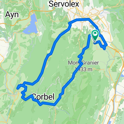
De 350 Clos du Prieuré, Saint-Baldoph à 40 Rue de la Françon, Voglans
A cycling route starting in Saint-Baldoph, Auvergne-Rhône-Alpes, France.
Overview
About this route
- 42 min
- Duration
- 12.5 km
- Distance
- 87 m
- Ascent
- 169 m
- Descent
- 17.8 km/h
- Avg. speed
- 347 m
- Max. altitude
Continue with Bikemap
Use, edit, or download this cycling route
You would like to ride De 350 Clos du Prieuré, Saint-Baldoph à 40 Rue de la Françon, Voglans or customize it for your own trip? Here is what you can do with this Bikemap route:
Free features
- Save this route as favorite or in collections
- Copy & plan your own version of this route
- Sync your route with Garmin or Wahoo
Premium features
Free trial for 3 days, or one-time payment. More about Bikemap Premium.
- Navigate this route on iOS & Android
- Export a GPX / KML file of this route
- Create your custom printout (try it for free)
- Download this route for offline navigation
Discover more Premium features.
Get Bikemap PremiumFrom our community
Other popular routes starting in Saint-Baldoph
 A 43, La Ravoire a 128 Impasse Gay Lussac, La Ravoire
- Distance
- 9 km
- Ascent
- 78 m
- Descent
- 72 m
- Location
- Saint-Baldoph, Auvergne-Rhône-Alpes, France
 Chambery-Col-de-Porte
- Distance
- 49.7 km
- Ascent
- 1,867 m
- Descent
- 861 m
- Location
- Saint-Baldoph, Auvergne-Rhône-Alpes, France
 RELAIS MONT DU CHAT, RETOUR ST BALDOPH COL EPINE
- Distance
- 79.1 km
- Ascent
- 1,804 m
- Descent
- 1,796 m
- Location
- Saint-Baldoph, Auvergne-Rhône-Alpes, France
 col du granier
- Distance
- 9.8 km
- Ascent
- 873 m
- Descent
- 73 m
- Location
- Saint-Baldoph, Auvergne-Rhône-Alpes, France
 3 Cols Marocaz, Des Prés, Frene
- Distance
- 105.2 km
- Ascent
- 1,679 m
- Descent
- 1,667 m
- Location
- Saint-Baldoph, Auvergne-Rhône-Alpes, France
 Chambery Revard, PLainpalais Challes
- Distance
- 77.6 km
- Ascent
- 1,587 m
- Descent
- 1,607 m
- Location
- Saint-Baldoph, Auvergne-Rhône-Alpes, France
 De Chemin de Revaison à Chemin du Forchet
- Distance
- 73.5 km
- Ascent
- 2,108 m
- Descent
- 2,130 m
- Location
- Saint-Baldoph, Auvergne-Rhône-Alpes, France
 De D9, La Ravoire à Rue de la Concorde, La Ravoire
- Distance
- 3.4 km
- Ascent
- 19 m
- Descent
- 36 m
- Location
- Saint-Baldoph, Auvergne-Rhône-Alpes, France
Open it in the app