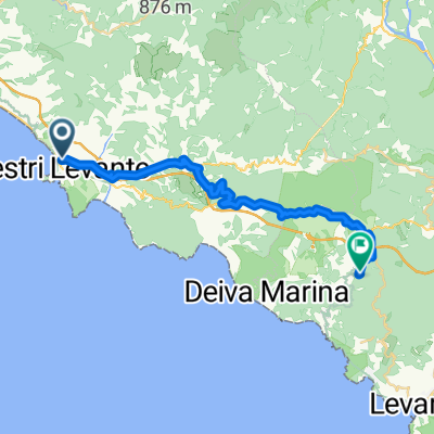
sestri levante rio maggiore
A cycling route starting in Sestri Levante, Liguria, Italy.
Overview
About this route
- -:--
- Duration
- 63.6 km
- Distance
- 3,830 m
- Ascent
- 3,594 m
- Descent
- ---
- Avg. speed
- 641 m
- Max. altitude
Route quality
Waytypes & surfaces along the route
Waytypes
Road
3.2 km
(5 %)
Quiet road
1.3 km
(2 %)
Surfaces
Paved
58.6 km
(92 %)
Asphalt
54.7 km
(86 %)
Paved (undefined)
3.8 km
(6 %)
Undefined
5.1 km
(8 %)
Continue with Bikemap
Use, edit, or download this cycling route
You would like to ride sestri levante rio maggiore or customize it for your own trip? Here is what you can do with this Bikemap route:
Free features
- Save this route as favorite or in collections
- Copy & plan your own version of this route
- Sync your route with Garmin or Wahoo
Premium features
Free trial for 3 days, or one-time payment. More about Bikemap Premium.
- Navigate this route on iOS & Android
- Export a GPX / KML file of this route
- Create your custom printout (try it for free)
- Download this route for offline navigation
Discover more Premium features.
Get Bikemap PremiumFrom our community
Other popular routes starting in Sestri Levante
- giro di prova. test
- Distance
- 35.6 km
- Ascent
- 986 m
- Descent
- 987 m
- Location
- Sestri Levante, Liguria, Italy
- Sestri-pisa
- Distance
- 125.9 km
- Ascent
- 756 m
- Descent
- 762 m
- Location
- Sestri Levante, Liguria, Italy
- giro di 100km da sestri
- Distance
- 126.7 km
- Ascent
- 2,067 m
- Descent
- 2,071 m
- Location
- Sestri Levante, Liguria, Italy
- Bracco-Levanto-Vara-Varese L.-Biscia-Monte Domenico_da Sestri L.
- Distance
- 129.2 km
- Ascent
- 2,229 m
- Descent
- 2,230 m
- Location
- Sestri Levante, Liguria, Italy
- Sestri 28-600
- Distance
- 28.3 km
- Ascent
- 602 m
- Descent
- 604 m
- Location
- Sestri Levante, Liguria, Italy
- Monte Castello
- Distance
- 20.6 km
- Ascent
- 548 m
- Descent
- 550 m
- Location
- Sestri Levante, Liguria, Italy
- Sestri-Bracco-Borghetto-Termine-Levanto-Guaitarola-Sestri
- Distance
- 98.4 km
- Ascent
- 1,807 m
- Descent
- 1,807 m
- Location
- Sestri Levante, Liguria, Italy
- Sestri Levante-sentiero Rocche S.Anna-Santa Giulia-Costarossa-Sestri L.
- Distance
- 22.2 km
- Ascent
- 518 m
- Descent
- 519 m
- Location
- Sestri Levante, Liguria, Italy
Open it in the app