

Witl + 4T 19.09.21
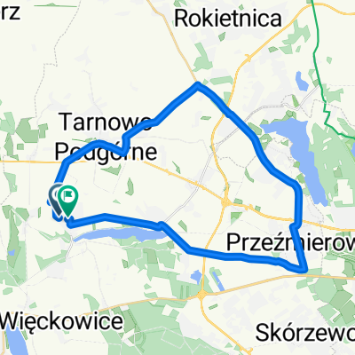
A cycling route starting in Tarnowo Podgórne, Greater Poland Voivodeship, Poland.
Overview
About this route
Witl + 4T 19.09.21
TP-Rokietnica-Glęczewo-Maniewo-Obornik-Szamotuły-Pólko-Kaźmierz-TP
- -:--
- Duration
- 82.3 km
- Distance
- 151 m
- Ascent
- 155 m
- Descent
- ---
- Avg. speed
- 100 m
- Max. altitude

Route quality
Waytypes & surfaces along the route
Waytypes
Road
37.9 km
(46 %)
Cycleway
13.2 km
(16 %)
Surfaces
Paved
69.2 km
(84 %)
Unpaved
1.6 km
(2 %)
Asphalt
60.1 km
(73 %)
Paved (undefined)
9.1 km
(11 %)
Continue with Bikemap
Use, edit, or download this cycling route
You would like to ride Witl + 4T 19.09.21 or customize it for your own trip? Here is what you can do with this Bikemap route:
Free features
- Save this route as favorite or in collections
- Copy & plan your own version of this route
- Split it into stages to create a multi-day tour
- Sync your route with Garmin or Wahoo
Premium features
Free trial for 3 days, or one-time payment. More about Bikemap Premium.
- Navigate this route on iOS & Android
- Export a GPX / KML file of this route
- Create your custom printout (try it for free)
- Download this route for offline navigation
Discover more Premium features.
Get Bikemap PremiumFrom our community
Other popular routes starting in Tarnowo Podgórne
 Pętla wokół Jeziora Kierskiego
- Distance
- 34.2 km
- Ascent
- 79 m
- Descent
- 79 m
- Location
- Tarnowo Podgórne, Greater Poland Voivodeship, Poland
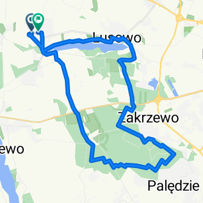
 Mała pętelka 4T
- Distance
- 56 km
- Ascent
- 177 m
- Descent
- 177 m
- Location
- Tarnowo Podgórne, Greater Poland Voivodeship, Poland
 Pętla 30 km
- Distance
- 31.1 km
- Ascent
- 71 m
- Descent
- 69 m
- Location
- Tarnowo Podgórne, Greater Poland Voivodeship, Poland
 Lusówko - Dopiewo
- Distance
- 11.7 km
- Ascent
- 18 m
- Descent
- 19 m
- Location
- Tarnowo Podgórne, Greater Poland Voivodeship, Poland
 trasa sobotnia 26.06.20221
- Distance
- 31.9 km
- Ascent
- 817 m
- Descent
- 775 m
- Location
- Tarnowo Podgórne, Greater Poland Voivodeship, Poland
 Tarnowo Podgórne i okolice.
- Distance
- 11.2 km
- Ascent
- 37 m
- Descent
- 60 m
- Location
- Tarnowo Podgórne, Greater Poland Voivodeship, Poland
 11.04.2021
- Distance
- 96.5 km
- Ascent
- 71 m
- Descent
- 69 m
- Location
- Tarnowo Podgórne, Greater Poland Voivodeship, Poland
 Lusówko, Zakrzewo
- Distance
- 27 km
- Ascent
- 124 m
- Descent
- 123 m
- Location
- Tarnowo Podgórne, Greater Poland Voivodeship, Poland
Open it in the app