broekpolder v2
A cycling route starting in Spijkenisse, South Holland, Netherlands.
Overview
About this route
- 2 h 37 min
- Duration
- 46.9 km
- Distance
- 32 m
- Ascent
- 32 m
- Descent
- 17.9 km/h
- Avg. speed
- 7 m
- Avg. speed
Route photos
Route quality
Waytypes & surfaces along the route
Waytypes
Cycleway
33.2 km
(71 %)
Quiet road
7 km
(15 %)
Surfaces
Paved
31.3 km
(67 %)
Unpaved
0.1 km
(<1 %)
Asphalt
27.9 km
(59 %)
Paving stones
3.4 km
(7 %)
Continue with Bikemap
Use, edit, or download this cycling route
You would like to ride broekpolder v2 or customize it for your own trip? Here is what you can do with this Bikemap route:
Free features
- Save this route as favorite or in collections
- Copy & plan your own version of this route
- Sync your route with Garmin or Wahoo
Premium features
Free trial for 3 days, or one-time payment. More about Bikemap Premium.
- Navigate this route on iOS & Android
- Export a GPX / KML file of this route
- Create your custom printout (try it for free)
- Download this route for offline navigation
Discover more Premium features.
Get Bikemap PremiumFrom our community
Other popular routes starting in Spijkenisse
- Rondje Rivierlaan
- Distance
- 35.3 km
- Ascent
- 0 m
- Descent
- 0 m
- Location
- Spijkenisse, South Holland, Netherlands
- Caracaspad, Rotterdam to Marconistraat 11, Rotterdam
- Distance
- 10.7 km
- Ascent
- 81 m
- Descent
- 70 m
- Location
- Spijkenisse, South Holland, Netherlands
- Spijkenisse - Berenplaat - Spui - Bernisse - Hartelkanaal - Maasboulevard
- Distance
- 31.9 km
- Ascent
- 17 m
- Descent
- 18 m
- Location
- Spijkenisse, South Holland, Netherlands
- Nizozemí- Spijkenisse - Oostvorne
- Distance
- 89 km
- Ascent
- 28 m
- Descent
- 29 m
- Location
- Spijkenisse, South Holland, Netherlands
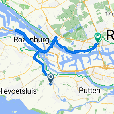
- Spui, Haringvliet, Bernisse, voedingskanaal, Oude Maas
- Distance
- 50.8 km
- Ascent
- 44 m
- Descent
- 44 m
- Location
- Spijkenisse, South Holland, Netherlands
- Trambaanpad
- Distance
- 41.7 km
- Ascent
- 4 m
- Descent
- 4 m
- Location
- Spijkenisse, South Holland, Netherlands
- Heinenoord
- Distance
- 37.2 km
- Ascent
- 42 m
- Descent
- 42 m
- Location
- Spijkenisse, South Holland, Netherlands
- Spui-Haringvliet-Zuidland-Bernisse-VV Spijkenisse
- Distance
- 43.7 km
- Ascent
- 51 m
- Descent
- 52 m
- Location
- Spijkenisse, South Holland, Netherlands
Open it in the app