

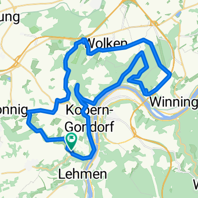
Mosel-koblenz-Rijn
A cycling route starting in Kobern-Gondorf, Rhineland-Palatinate, Germany.
Overview
About this route
- -:--
- Duration
- 47.3 km
- Distance
- 347 m
- Ascent
- 344 m
- Descent
- ---
- Avg. speed
- 328 m
- Max. altitude

Route quality
Waytypes & surfaces along the route
Waytypes
Road
9.9 km
(21 %)
Quiet road
7.1 km
(15 %)
Surfaces
Paved
39.7 km
(84 %)
Unpaved
1.9 km
(4 %)
Asphalt
36.9 km
(78 %)
Paved (undefined)
2.4 km
(5 %)
Continue with Bikemap
Use, edit, or download this cycling route
You would like to ride Mosel-koblenz-Rijn or customize it for your own trip? Here is what you can do with this Bikemap route:
Free features
- Save this route as favorite or in collections
- Copy & plan your own version of this route
- Sync your route with Garmin or Wahoo
Premium features
Free trial for 3 days, or one-time payment. More about Bikemap Premium.
- Navigate this route on iOS & Android
- Export a GPX / KML file of this route
- Create your custom printout (try it for free)
- Download this route for offline navigation
Discover more Premium features.
Get Bikemap PremiumFrom our community
Other popular routes starting in Kobern-Gondorf
 schöne tour nachgefahren 2
- Distance
- 30.7 km
- Ascent
- 536 m
- Descent
- 536 m
- Location
- Kobern-Gondorf, Rhineland-Palatinate, Germany
 mtb kobern lonnig wolken gondorf
- Distance
- 29.8 km
- Ascent
- 590 m
- Descent
- 590 m
- Location
- Kobern-Gondorf, Rhineland-Palatinate, Germany
 KOBERN - KOBLENZ & RETOUR
- Distance
- 17.6 km
- Ascent
- 86 m
- Descent
- 87 m
- Location
- Kobern-Gondorf, Rhineland-Palatinate, Germany
 Kobern Gondorf - Trabentrarbach
- Distance
- 70 km
- Ascent
- 581 m
- Descent
- 566 m
- Location
- Kobern-Gondorf, Rhineland-Palatinate, Germany
 730km teil 2
- Distance
- 728.5 km
- Ascent
- 6,746 m
- Descent
- 6,751 m
- Location
- Kobern-Gondorf, Rhineland-Palatinate, Germany
 Kobern Münstermaifeld Schrumpftal Kobern
- Distance
- 31.7 km
- Ascent
- 934 m
- Descent
- 939 m
- Location
- Kobern-Gondorf, Rhineland-Palatinate, Germany
 Obermarkstraße 51, Kobern-Gondorf to Weinbergstraße 3, Moselkern
- Distance
- 16.9 km
- Ascent
- 277 m
- Descent
- 256 m
- Location
- Kobern-Gondorf, Rhineland-Palatinate, Germany
 Koblenz 15km Moselaufwärts
- Distance
- 37.4 km
- Ascent
- 111 m
- Descent
- 119 m
- Location
- Kobern-Gondorf, Rhineland-Palatinate, Germany
Open it in the app