

Podbreziny-Smrečany-Jalovec-pod horou-Benušovce-Lip.Trnovec-L.Mikuláš
A cycling route starting in Liptovský Mikuláš, Žilina Region, Slovakia.
Overview
About this route
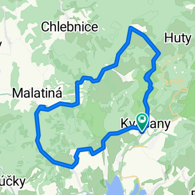
The route traditionally starts at Podbreziny /housing estate in Liptovský Mikuláš/ towards Smrečany, where we turn near the old church and continue into the fields. After about 600-700 m, at the first little bridge, we turn left across a field road to the other side of the field. On the left side, a steep, worn path appears that leads down to the village. By turning slightly left, we leave the village towards the main connection between Liptovský Mikuláš and the Jalovecká valley, turning left into the valley. Upon reaching the parking area, a gentle ascent awaits us on the left. Halfway up, I started to push. Overall, it can be managed in about 20 minutes, even pushing. The reward is a beautiful view back. At the hotel 'Dumbier', we turn left. The path is asphalted, so it can also be traveled with road touring bicycles. Through a gently rolling route, we reach the hunters' lodge, which cannot be mistaken, it has the inscription 'greetings to the forest'. There is an option to see a small waterfall that is about 50 m behind the lodge. We continue further through the landscape, sometimes through woods or fields, until we arrive at a crossroads. One route to the left leads through a shortened version to Benušovce and the other longer through 'Vyšné Matiašovce', this route then connects behind Matiašovce to the road towards Benušovce. At this point, both routes meet. Exiting the forest begins an uncomfortable descent down towards Benušovce where the rear is higher than the nose. It is the only point on the route that is slightly unpleasant due to its gradient. The rest of the way is just rolling landscape that rewards us with beautiful views of the meadows, Lip. Maru, but also the Tatra mountain range.
- -:--
- Duration
- 34.7 km
- Distance
- 478 m
- Ascent
- 478 m
- Descent
- ---
- Avg. speed
- ---
- Max. altitude
Route highlights
Points of interest along the route
Point of interest after 10.8 km
Point of interest after 15.5 km
Point of interest after 16.8 km
Point of interest after 18.1 km
Point of interest after 24.9 km
Continue with Bikemap
Use, edit, or download this cycling route
You would like to ride Podbreziny-Smrečany-Jalovec-pod horou-Benušovce-Lip.Trnovec-L.Mikuláš or customize it for your own trip? Here is what you can do with this Bikemap route:
Free features
- Save this route as favorite or in collections
- Copy & plan your own version of this route
- Sync your route with Garmin or Wahoo
Premium features
Free trial for 3 days, or one-time payment. More about Bikemap Premium.
- Navigate this route on iOS & Android
- Export a GPX / KML file of this route
- Create your custom printout (try it for free)
- Download this route for offline navigation
Discover more Premium features.
Get Bikemap PremiumFrom our community
Other popular routes starting in Liptovský Mikuláš
 LIPTOVSKÝ MIKULÁŠ:-Podbreziny.Lip.Ondrej-Pol.letisko-Račková dol.-Hotel Mier-lúky Jakubovia-Jakubovany-Lip.Ondrej-Benadiková-Podbreziny CLONED FROM ROUTE 100008
- Distance
- 30.8 km
- Ascent
- 405 m
- Descent
- 406 m
- Location
- Liptovský Mikuláš, Žilina Region, Slovakia
 D06LiMiBaBy
- Distance
- 97.2 km
- Ascent
- 957 m
- Descent
- 999 m
- Location
- Liptovský Mikuláš, Žilina Region, Slovakia
 1024_Mlynské kolesá v Oblazoch
- Distance
- 38.2 km
- Ascent
- 822 m
- Descent
- 822 m
- Location
- Liptovský Mikuláš, Žilina Region, Slovakia
 2018 - Přejezd slovenských hor
- Distance
- 392.9 km
- Ascent
- 2,452 m
- Descent
- 2,758 m
- Location
- Liptovský Mikuláš, Žilina Region, Slovakia
 Okruh Penzión Alžbeta - Žiarska chata
- Distance
- 46.4 km
- Ascent
- 944 m
- Descent
- 944 m
- Location
- Liptovský Mikuláš, Žilina Region, Slovakia
 Okolo Tatier - 47h (8.7-10.7.2016)
- Distance
- 219.7 km
- Ascent
- 3,356 m
- Descent
- 2,208 m
- Location
- Liptovský Mikuláš, Žilina Region, Slovakia
 hrad
hrad- Distance
- 17 km
- Ascent
- 370 m
- Descent
- 366 m
- Location
- Liptovský Mikuláš, Žilina Region, Slovakia
 Demänova-Lubela -Vlachy-Demänová
- Distance
- 33.1 km
- Ascent
- 359 m
- Descent
- 358 m
- Location
- Liptovský Mikuláš, Žilina Region, Slovakia
Open it in the app