
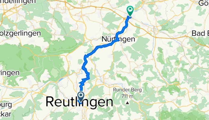
Reutlingen Nürtingen Wendlingen 32km 110hm
A cycling route starting in Reutlingen, Baden-Wurttemberg, Germany.
Overview
About this route
This is the return trip of the tour from Stuttgart-Möhringen to Reutlingen. It goes via Nürtingen to Wendlingen, as from there you can travel directly without changing trains to Stuttgart-Vaihingen on the S-Bahn. And from there it’s only a few kilometers back to Möhringen.
Leaving Reutlingen isn’t particularly nice at first, but once you reach the Neckar, you go through a beautiful river landscape.
Just before Nürtingen, there’s a small garden restaurant right along the route, where there’s sometimes live music (Beutesee Kiosk - delicious x outside, Beutwang 15, 72622 Nürtingen). Nürtingen itself is also a lovely place with good dining options for a stop.
- -:--
- Duration
- 32.4 km
- Distance
- 90 m
- Ascent
- 217 m
- Descent
- ---
- Avg. speed
- 395 m
- Max. altitude

Route quality
Waytypes & surfaces along the route
Waytypes
Track
12 km
(37 %)
Path
6.5 km
(20 %)
Surfaces
Paved
28.9 km
(89 %)
Unpaved
2.9 km
(9 %)
Asphalt
27.9 km
(86 %)
Loose gravel
2.3 km
(7 %)
Continue with Bikemap
Use, edit, or download this cycling route
You would like to ride Reutlingen Nürtingen Wendlingen 32km 110hm or customize it for your own trip? Here is what you can do with this Bikemap route:
Free features
- Save this route as favorite or in collections
- Copy & plan your own version of this route
- Sync your route with Garmin or Wahoo
Premium features
Free trial for 3 days, or one-time payment. More about Bikemap Premium.
- Navigate this route on iOS & Android
- Export a GPX / KML file of this route
- Create your custom printout (try it for free)
- Download this route for offline navigation
Discover more Premium features.
Get Bikemap PremiumFrom our community
Other popular routes starting in Reutlingen
 RT-Göllesberg-Alpenaussicht-Gruorn-Höchster-Fischbachtal-Urach-Glems-RT
- Distance
- 78.8 km
- Ascent
- 795 m
- Descent
- 800 m
- Location
- Reutlingen, Baden-Wurttemberg, Germany
 Reutlingen - Lindenhof - Stahleck - Lichtenstein - Kalkofen - Stuhlsteige - Reutlingen
- Distance
- 40.9 km
- Ascent
- 708 m
- Descent
- 708 m
- Location
- Reutlingen, Baden-Wurttemberg, Germany
 Schloss Lichtenstein Tour
- Distance
- 32.1 km
- Ascent
- 468 m
- Descent
- 468 m
- Location
- Reutlingen, Baden-Wurttemberg, Germany
 Lautertal
- Distance
- 75.8 km
- Ascent
- 952 m
- Descent
- 945 m
- Location
- Reutlingen, Baden-Wurttemberg, Germany
 Ausflug zum Neckar auch mit Kinder und Anhänger
- Distance
- 22.1 km
- Ascent
- 167 m
- Descent
- 187 m
- Location
- Reutlingen, Baden-Wurttemberg, Germany
 RT-St.Johann-Münsingen-Hohenstein-Undingen-Gönningen-RT
- Distance
- 84.1 km
- Ascent
- 830 m
- Descent
- 832 m
- Location
- Reutlingen, Baden-Wurttemberg, Germany
 Holzgerlingen - Ebersbach an der Fils
- Distance
- 48.4 km
- Ascent
- 594 m
- Descent
- 684 m
- Location
- Reutlingen, Baden-Wurttemberg, Germany
 Reutlingen - Neckartal, Aichtal, Schönbuch, Tübingen - Reutlingen
- Distance
- 59 km
- Ascent
- 562 m
- Descent
- 597 m
- Location
- Reutlingen, Baden-Wurttemberg, Germany
Open it in the app