

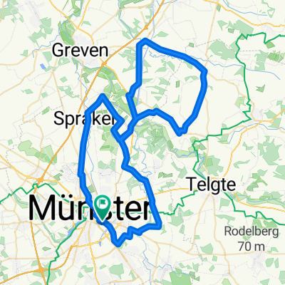
Campingplatz - Emsauen- u. Kanal-Tour
A cycling route starting in Münster, North Rhine-Westphalia, Germany.
Overview
About this route
- -:--
- Duration
- 53.2 km
- Distance
- 182 m
- Ascent
- 179 m
- Descent
- ---
- Avg. speed
- 72 m
- Max. altitude

Route quality
Waytypes & surfaces along the route
Waytypes
Quiet road
26.6 km
(50 %)
Path
10.6 km
(20 %)
Surfaces
Paved
33.5 km
(63 %)
Unpaved
13.8 km
(26 %)
Asphalt
31.9 km
(60 %)
Gravel
10.6 km
(20 %)
Route highlights
Points of interest along the route
Point of interest after 3.2 km
Werse
Photo after 3.2 km
Point of interest after 3.3 km
Alte Pleistermühle
Accommodation after 3.3 km
Landgasthof Pleister-Mühle
Accommodation after 3.4 km
Start und Ziel: Parkplatz Pleister Mühle, Pleistermühlenweg, Münster
Point of interest after 7.9 km
Schaustelle Kanal
Point of interest after 8.2 km
Schleuse Münster
Point of interest after 10 km
Münster-Coerde
Point of interest after 13.7 km
Infocentrum Rieselfelder Münster
Point of interest after 15.5 km
Biotop Aussenausstellung
Point of interest after 15.6 km
Rieselfelder Münster
Point of interest after 15.9 km
Beobachtungsplattform Stausee (Rieselfelder Münster)
Point of interest after 17.6 km
Dortmund-Ems-Kanal
Point of interest after 18.1 km
Bootscenter Münster
Point of interest after 21.1 km
NSG Emsaue
Point of interest after 23.6 km
Ems-Aue Ringemanns Hals
Point of interest after 27.1 km
Aussichtspunkt Ems-Aue Ringemanns Hals
Point of interest after 29.4 km
Bever-Aue
Point of interest after 29.6 km
Haus Langen
Point of interest after 29.6 km
Doppelmühle Haus Langen
Point of interest after 30.6 km
Ems
Point of interest after 31.1 km
Schulbauernhof Emshof
Point of interest after 33.7 km
Weinende Frauen
Accommodation after 34.3 km
Markt-Cafe
Point of interest after 34.3 km
Clemenskirche
Point of interest after 34.3 km
Ems-Wehr Bernsmeyer-Haus
Photo after 34.3 km
Böttcherhus
Point of interest after 34.3 km
Gnadenkapelle
Point of interest after 36.5 km
Rathaus
Point of interest after 36.6 km
Telgte
Point of interest after 38.6 km
Ems
Continue with Bikemap
Use, edit, or download this cycling route
You would like to ride Campingplatz - Emsauen- u. Kanal-Tour or customize it for your own trip? Here is what you can do with this Bikemap route:
Free features
- Save this route as favorite or in collections
- Copy & plan your own version of this route
- Sync your route with Garmin or Wahoo
Premium features
Free trial for 3 days, or one-time payment. More about Bikemap Premium.
- Navigate this route on iOS & Android
- Export a GPX / KML file of this route
- Create your custom printout (try it for free)
- Download this route for offline navigation
Discover more Premium features.
Get Bikemap PremiumFrom our community
Other popular routes starting in Münster
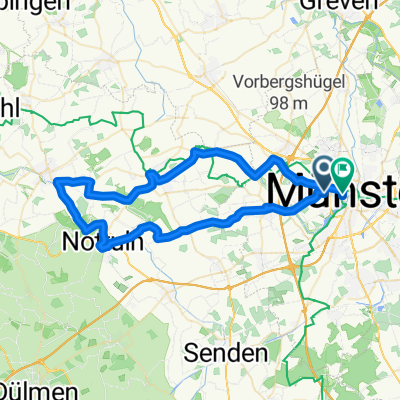
 Erste Münsterland Giro.2011 Erkundungstour
- Distance
- 66.9 km
- Ascent
- 54 m
- Descent
- 54 m
- Location
- Münster, North Rhine-Westphalia, Germany
 Kurze Münsterlandrunde
- Distance
- 38.7 km
- Ascent
- 109 m
- Descent
- 109 m
- Location
- Münster, North Rhine-Westphalia, Germany
 MS-Rieselfelder-Telgte-MS
- Distance
- 52 km
- Ascent
- 99 m
- Descent
- 99 m
- Location
- Münster, North Rhine-Westphalia, Germany
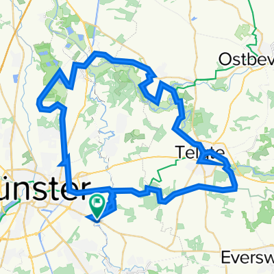
 Giro 2010 55km
- Distance
- 56 km
- Ascent
- 238 m
- Descent
- 242 m
- Location
- Münster, North Rhine-Westphalia, Germany
 Campingplatz - Emsauen- u. Kanal-Tour
- Distance
- 53.2 km
- Ascent
- 182 m
- Descent
- 179 m
- Location
- Münster, North Rhine-Westphalia, Germany
 Münster - Telgte - Münster
- Distance
- 39.6 km
- Ascent
- 43 m
- Descent
- 44 m
- Location
- Münster, North Rhine-Westphalia, Germany
 Samstagnachmittagsrunde: 117 km Teuto/Schafberg
- Distance
- 117.5 km
- Ascent
- 635 m
- Descent
- 651 m
- Location
- Münster, North Rhine-Westphalia, Germany
 MS 01
MS 01- Distance
- 35.9 km
- Ascent
- 48 m
- Descent
- 46 m
- Location
- Münster, North Rhine-Westphalia, Germany
Open it in the app