

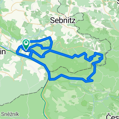
Sächsisch-Böhmische -Schweiz
A cycling route starting in Bad Schandau, Saxony, Germany.
Overview
About this route
Kirnitzschtal-Vysoka Lipa-Dolsky mlyn-Rusova-Hrensko-Bad Schandau
Schöne Runde durch die Sächsisch-Böhmische-Schweiz.
Wenn Straße wenig Verkehr. Radwege.
Von Bad Schandau aus dem Verlauf der Kirnitzsch folgen bis zum Grenzübergang (Rabensteine - Hinter Dittersbach).
Dem Weg folgen bis zur Gabelung, links halten auf Radweg (RW) 3030
gerade aus auf RW 3029 (Vysoka Lipa)
Links halten auf RW 21 diesen Folgen (Hauptstraße) bis ins Tal, dort rechts auf
RW 3076 abbiegen, diesen folgen
(bergan ein kleines Stück schieben angeagt) :-)
Hinter Kamenická Stran der gelben Markierung folgen (Links halten Waldweg) bis Rusova ( Rosendorf).
Vorsicht freilaufende Dackel!!!!!!!!!!!!!!
Dem Straßenverlauf weiter folgen über Janov nach Hrensko, zurück nach Bad Schandau
- -:--
- Duration
- 58.1 km
- Distance
- 533 m
- Ascent
- 533 m
- Descent
- ---
- Avg. speed
- ---
- Max. altitude

Route quality
Waytypes & surfaces along the route
Waytypes
Road
19.9 km
(34 %)
Track
14.3 km
(25 %)
Surfaces
Paved
48 km
(83 %)
Unpaved
7.3 km
(12 %)
Asphalt
43.7 km
(75 %)
Gravel
4.6 km
(8 %)
Continue with Bikemap
Use, edit, or download this cycling route
You would like to ride Sächsisch-Böhmische -Schweiz or customize it for your own trip? Here is what you can do with this Bikemap route:
Free features
- Save this route as favorite or in collections
- Copy & plan your own version of this route
- Sync your route with Garmin or Wahoo
Premium features
Free trial for 3 days, or one-time payment. More about Bikemap Premium.
- Navigate this route on iOS & Android
- Export a GPX / KML file of this route
- Create your custom printout (try it for free)
- Download this route for offline navigation
Discover more Premium features.
Get Bikemap PremiumFrom our community
Other popular routes starting in Bad Schandau
 Elbet
Elbet- Distance
- 60.2 km
- Ascent
- 923 m
- Descent
- 932 m
- Location
- Bad Schandau, Saxony, Germany
 Elbsandsteintour
- Distance
- 68.3 km
- Ascent
- 828 m
- Descent
- 828 m
- Location
- Bad Schandau, Saxony, Germany
 Bad Schandau - Johnsdorf
- Distance
- 52.6 km
- Ascent
- 945 m
- Descent
- 657 m
- Location
- Bad Schandau, Saxony, Germany
 GT2-13 Schmilka-Zittau
- Distance
- 95.7 km
- Ascent
- 1,263 m
- Descent
- 1,091 m
- Location
- Bad Schandau, Saxony, Germany
 unlöschbare MTB-Tour
- Distance
- 68.2 km
- Ascent
- 1,428 m
- Descent
- 1,420 m
- Location
- Bad Schandau, Saxony, Germany
 Bad Schandau nach Dresden
- Distance
- 44.7 km
- Ascent
- 235 m
- Descent
- 337 m
- Location
- Bad Schandau, Saxony, Germany
 Elberadweg
- Distance
- 763.1 km
- Ascent
- 150 m
- Descent
- 287 m
- Location
- Bad Schandau, Saxony, Germany
 Elberadweg
- Distance
- 773.3 km
- Ascent
- 237 m
- Descent
- 394 m
- Location
- Bad Schandau, Saxony, Germany
Open it in the app