

E-MTB-Schmankerl-Tour
A cycling route starting in Tegernsee, Bavaria, Germany.
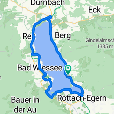
Overview
About this route
Die E-MTB-Runde lädt Sie auf eine kulinarische Reise durch das Tegernseer Tal und die Tegernseer Bergwelt ein, größtenteils entlang von Forstwegen und Nebenstraßen.
- -:--
- Duration
- 44.5 km
- Distance
- 633 m
- Ascent
- 633 m
- Descent
- ---
- Avg. speed
- ---
- Max. altitude

Route quality
Waytypes & surfaces along the route
Waytypes
Track
22.8 km
(51 %)
Quiet road
10.6 km
(24 %)
Surfaces
Paved
18.8 km
(42 %)
Unpaved
22.5 km
(51 %)
Asphalt
17.5 km
(39 %)
Gravel
14.9 km
(34 %)
Continue with Bikemap
Use, edit, or download this cycling route
You would like to ride E-MTB-Schmankerl-Tour or customize it for your own trip? Here is what you can do with this Bikemap route:
Free features
- Save this route as favorite or in collections
- Copy & plan your own version of this route
- Sync your route with Garmin or Wahoo
Premium features
Free trial for 3 days, or one-time payment. More about Bikemap Premium.
- Navigate this route on iOS & Android
- Export a GPX / KML file of this route
- Create your custom printout (try it for free)
- Download this route for offline navigation
Discover more Premium features.
Get Bikemap PremiumFrom our community
Other popular routes starting in Tegernsee
 Transalp 2008
- Distance
- 389.3 km
- Ascent
- 4,432 m
- Descent
- 5,129 m
- Location
- Tegernsee, Bavaria, Germany
 21.6. München to Tegernsee
- Distance
- 90.1 km
- Ascent
- 742 m
- Descent
- 966 m
- Location
- Tegernsee, Bavaria, Germany
 B03TÖL-Tegernsee-Hausham (über Kreuzberg)
- Distance
- 26.5 km
- Ascent
- 632 m
- Descent
- 632 m
- Location
- Tegernsee, Bavaria, Germany
 22.6. Tegernsee - Maurach
- Distance
- 51.4 km
- Ascent
- 1,168 m
- Descent
- 969 m
- Location
- Tegernsee, Bavaria, Germany
 Tegernsee-Valepp-Spitzingsattel-Schliersee-Tegernsee
- Distance
- 55.4 km
- Ascent
- 681 m
- Descent
- 686 m
- Location
- Tegernsee, Bavaria, Germany
 Seerundweg Tegernsee (Tour Nr. 32 aus dem"RadlTraum Süd")
- Distance
- 20.9 km
- Ascent
- 139 m
- Descent
- 139 m
- Location
- Tegernsee, Bavaria, Germany
 Seestraße 10, Tegernsee nach Schönwerthstraße 20–42, München
- Distance
- 49.9 km
- Ascent
- 302 m
- Descent
- 484 m
- Location
- Tegernsee, Bavaria, Germany
 Tegernsee-Valepp-Spitzingsattel-Schliersee-Tegernsee
- Distance
- 49.1 km
- Ascent
- 670 m
- Descent
- 673 m
- Location
- Tegernsee, Bavaria, Germany
Open it in the app