

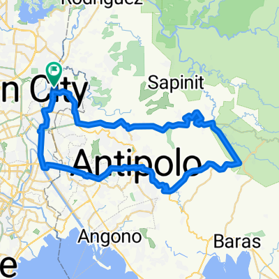
Route from 176–188 General Ordonez, Marikina City
A cycling route starting in Antipolo City, Calabarzon, Philippines.
Overview
About this route
- 3 h 41 min
- Duration
- 49.1 km
- Distance
- 625 m
- Ascent
- 387 m
- Descent
- 13.4 km/h
- Avg. speed
- 273 m
- Max. altitude

Route quality
Waytypes & surfaces along the route
Waytypes
Quiet road
15.2 km
(31 %)
Road
4.9 km
(10 %)
Surfaces
Paved
23.1 km
(47 %)
Asphalt
15.7 km
(32 %)
Concrete
7.4 km
(15 %)
Undefined
26 km
(53 %)
Continue with Bikemap
Use, edit, or download this cycling route
You would like to ride Route from 176–188 General Ordonez, Marikina City or customize it for your own trip? Here is what you can do with this Bikemap route:
Free features
- Save this route as favorite or in collections
- Copy & plan your own version of this route
- Sync your route with Garmin or Wahoo
Premium features
Free trial for 3 days, or one-time payment. More about Bikemap Premium.
- Navigate this route on iOS & Android
- Export a GPX / KML file of this route
- Create your custom printout (try it for free)
- Download this route for offline navigation
Discover more Premium features.
Get Bikemap PremiumFrom our community
Other popular routes starting in Antipolo City
 Antipolo Ride
- Distance
- 16.9 km
- Ascent
- 325 m
- Descent
- 170 m
- Location
- Antipolo City, Calabarzon, Philippines
 F. Balagtas 23, Marikina to F. Balagtas 5-E, Makati
- Distance
- 15.6 km
- Ascent
- 112 m
- Descent
- 130 m
- Location
- Antipolo City, Calabarzon, Philippines
 Antipolo to Sacrepante, Mandaluyong
- Distance
- 15.1 km
- Ascent
- 107 m
- Descent
- 125 m
- Location
- Antipolo City, Calabarzon, Philippines
 Santan to Santan Street
- Distance
- 82 km
- Ascent
- 501 m
- Descent
- 526 m
- Location
- Antipolo City, Calabarzon, Philippines
 OPLAN Balik Totoy
- Distance
- 4.8 km
- Ascent
- 23 m
- Descent
- 19 m
- Location
- Antipolo City, Calabarzon, Philippines
 bike tour through Marikina
- Distance
- 20.2 km
- Ascent
- 29 m
- Descent
- 29 m
- Location
- Antipolo City, Calabarzon, Philippines
 route antemar loop
- Distance
- 63.1 km
- Ascent
- 572 m
- Descent
- 571 m
- Location
- Antipolo City, Calabarzon, Philippines
 Crest Lane, San Mateo to Mataas Na Lupa 1004, Manila
- Distance
- 22.9 km
- Ascent
- 92 m
- Descent
- 238 m
- Location
- Antipolo City, Calabarzon, Philippines
Open it in the app