

Elend-Trail
A cycling route starting in Braunlage, Lower Saxony, Germany.
Overview
About this route
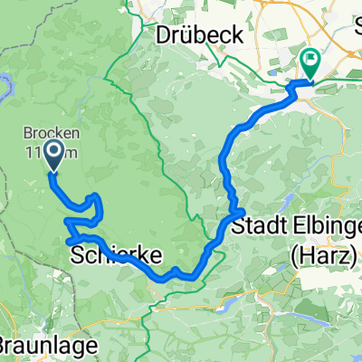
Traveled by car from QLb. Parked shortly after Elend and started. I actually wanted to ride a different route but oh well... no warm-up (which I personally kind of regretted :D), because the climb starts immediately. Passing two cliffs, there's about 1 km of nicely rocky and rooty descent down to Elend... including a short section of switchbacks. Then I crossed to the other side of the road and went a bit through the forest. At some point, the path ended and it became off-trail. If that doesn't bother you, in my opinion it's a nice route with about 90% singletrack (my estimate)... unfortunately the route is a bit short but you can always ride it twice :D
- -:--
- Duration
- 16.5 km
- Distance
- 316 m
- Ascent
- 316 m
- Descent
- ---
- Avg. speed
- ---
- Max. altitude
Continue with Bikemap
Use, edit, or download this cycling route
You would like to ride Elend-Trail or customize it for your own trip? Here is what you can do with this Bikemap route:
Free features
- Save this route as favorite or in collections
- Copy & plan your own version of this route
- Sync your route with Garmin or Wahoo
Premium features
Free trial for 3 days, or one-time payment. More about Bikemap Premium.
- Navigate this route on iOS & Android
- Export a GPX / KML file of this route
- Create your custom printout (try it for free)
- Download this route for offline navigation
Discover more Premium features.
Get Bikemap PremiumFrom our community
Other popular routes starting in Braunlage
 Braunlage: Trailfeuerwerk!
- Distance
- 44.1 km
- Ascent
- 847 m
- Descent
- 858 m
- Location
- Braunlage, Lower Saxony, Germany
 Braunlage 60
- Distance
- 59.8 km
- Ascent
- 1,308 m
- Descent
- 1,307 m
- Location
- Braunlage, Lower Saxony, Germany
 Elend-Trail
- Distance
- 16.5 km
- Ascent
- 316 m
- Descent
- 316 m
- Location
- Braunlage, Lower Saxony, Germany
 1. Harzer Runde 0509
- Distance
- 56.3 km
- Ascent
- 953 m
- Descent
- 960 m
- Location
- Braunlage, Lower Saxony, Germany
 MTBKS - Braunlage 1
- Distance
- 44.3 km
- Ascent
- 1,157 m
- Descent
- 1,163 m
- Location
- Braunlage, Lower Saxony, Germany
 Braunlage - Königshütte - Brocken - Zorge - Braunlage
- Distance
- 94.5 km
- Ascent
- 1,348 m
- Descent
- 1,395 m
- Location
- Braunlage, Lower Saxony, Germany
 Brocken - Wernigerode Teil 2
- Distance
- 28.1 km
- Ascent
- 113 m
- Descent
- 978 m
- Location
- Braunlage, Lower Saxony, Germany
 Harz 1. dag 2011
- Distance
- 114.7 km
- Ascent
- 1,559 m
- Descent
- 1,559 m
- Location
- Braunlage, Lower Saxony, Germany
Open it in the app