

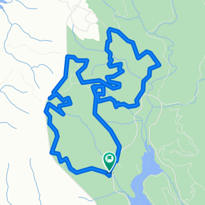
Sassafras 'Scenic'
A cycling route starting in Clemson, South Carolina, United States.
Overview
About this route
- -:--
- Duration
- 124.6 km
- Distance
- 2,233 m
- Ascent
- 2,224 m
- Descent
- ---
- Avg. speed
- 1,070 m
- Max. altitude

Route quality
Waytypes & surfaces along the route
Waytypes
Quiet road
51.1 km
(41 %)
Road
33.6 km
(27 %)
Surfaces
Paved
102.2 km
(82 %)
Asphalt
102.2 km
(82 %)
Undefined
22.4 km
(18 %)
Continue with Bikemap
Use, edit, or download this cycling route
You would like to ride Sassafras 'Scenic' or customize it for your own trip? Here is what you can do with this Bikemap route:
Free features
- Save this route as favorite or in collections
- Copy & plan your own version of this route
- Split it into stages to create a multi-day tour
- Sync your route with Garmin or Wahoo
Premium features
Free trial for 3 days, or one-time payment. More about Bikemap Premium.
- Navigate this route on iOS & Android
- Export a GPX / KML file of this route
- Create your custom printout (try it for free)
- Download this route for offline navigation
Discover more Premium features.
Get Bikemap PremiumFrom our community
Other popular routes starting in Clemson
 Easy ride in Clemson
- Distance
- 19.2 km
- Ascent
- 19 m
- Descent
- 45 m
- Location
- Clemson, South Carolina, United States
 MTB tour from September 13, 4:52 PM
- Distance
- 12 km
- Ascent
- 205 m
- Descent
- 205 m
- Location
- Clemson, South Carolina, United States
 Brief ride from October 18, 4:57 PM
- Distance
- 6.8 km
- Ascent
- 111 m
- Descent
- 110 m
- Location
- Clemson, South Carolina, United States
 century ---> clemson to greenville and back
- Distance
- 167.1 km
- Ascent
- 1,963 m
- Descent
- 1,963 m
- Location
- Clemson, South Carolina, United States
 14 Mile Singing Pines Out and Back
- Distance
- 22.5 km
- Ascent
- 276 m
- Descent
- 276 m
- Location
- Clemson, South Carolina, United States
 Sassafras 'Scenic'
- Distance
- 124.6 km
- Ascent
- 2,233 m
- Descent
- 2,224 m
- Location
- Clemson, South Carolina, United States
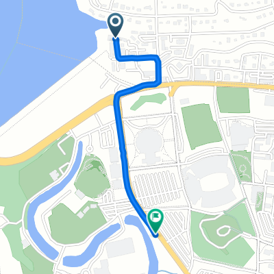 123 Houston St, Clemson to Perimeter Rd, Clemson
- Distance
- 2 km
- Ascent
- 10 m
- Descent
- 23 m
- Location
- Clemson, South Carolina, United States
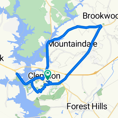 120 Daniel Dr, Clemson to 120 Daniel Dr, Clemson
- Distance
- 24 km
- Ascent
- 311 m
- Descent
- 311 m
- Location
- Clemson, South Carolina, United States
Open it in the app