

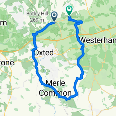
Home - Woldingham School 7.3km
A cycling route starting in Woldingham, England, United Kingdom.
Overview
About this route
- -:--
- Duration
- 5.7 km
- Distance
- 170 m
- Ascent
- 140 m
- Descent
- ---
- Avg. speed
- 208 m
- Max. altitude
Route quality
Waytypes & surfaces along the route
Waytypes
Busy road
2.1 km
(36 %)
Access road
1.4 km
(24 %)
Surfaces
Paved
3.3 km
(57 %)
Unpaved
0.1 km
(2 %)
Asphalt
3.3 km
(57 %)
Ground
0.1 km
(2 %)
Undefined
2.3 km
(41 %)
Route highlights
Points of interest along the route
Point of interest after 0.5 km
Woldingham Tennis Club
Continue with Bikemap
Use, edit, or download this cycling route
You would like to ride Home - Woldingham School 7.3km or customize it for your own trip? Here is what you can do with this Bikemap route:
Free features
- Save this route as favorite or in collections
- Copy & plan your own version of this route
- Sync your route with Garmin or Wahoo
Premium features
Free trial for 3 days, or one-time payment. More about Bikemap Premium.
- Navigate this route on iOS & Android
- Export a GPX / KML file of this route
- Create your custom printout (try it for free)
- Download this route for offline navigation
Discover more Premium features.
Get Bikemap PremiumFrom our community
Other popular routes starting in Woldingham
 Home - Woldingham School 7.3km
- Distance
- 5.7 km
- Ascent
- 170 m
- Descent
- 140 m
- Location
- Woldingham, England, United Kingdom
 Home - Woldingham 7.3km
- Distance
- 7.3 km
- Ascent
- 94 m
- Descent
- 142 m
- Location
- Woldingham, England, United Kingdom
 NDW Part2
- Distance
- 59.7 km
- Ascent
- 423 m
- Descent
- 586 m
- Location
- Woldingham, England, United Kingdom
 Woodlingham Downs Circular
- Distance
- 9.8 km
- Ascent
- 244 m
- Descent
- 240 m
- Location
- Woldingham, England, United Kingdom
 Little Kemp, Upper Court Road, Caterham to Toad Hall, Wire Mill Lane, Lingfield
- Distance
- 18.7 km
- Ascent
- 0 m
- Descent
- 170 m
- Location
- Woldingham, England, United Kingdom
 Woldingham Station to Newstead Rise 22
- Distance
- 7.7 km
- Ascent
- 125 m
- Descent
- 105 m
- Location
- Woldingham, England, United Kingdom
 Little Kemp, Upper Court Road, Caterham to The Ridge, Caterham
- Distance
- 1.8 km
- Ascent
- 25 m
- Descent
- 47 m
- Location
- Woldingham, England, United Kingdom
 Oxted lap extension
- Distance
- 22.3 km
- Ascent
- 309 m
- Descent
- 327 m
- Location
- Woldingham, England, United Kingdom
Open it in the app