

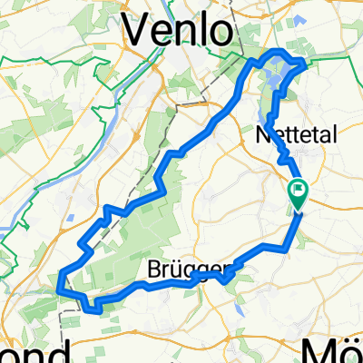
Venlo-Roermond
A cycling route starting in Nettetal, North Rhine-Westphalia, Germany.
Overview
About this route
Von Kaldenkirchen Bhf nach Venlo über die Maasbrücke auf die Westseite. Dort entland ger Maas bis Kessel. Mit der Fähre nach Bessel und weiter auf der Ostseite entlang der Maas bis Roermond. Zur Grenze an dieser entlang bis Kaldenkirchen Bhf.
- -:--
- Duration
- 66.8 km
- Distance
- 100 m
- Ascent
- 98 m
- Descent
- ---
- Avg. speed
- ---
- Avg. speed
Route quality
Waytypes & surfaces along the route
Waytypes
Quiet road
45.6 km
(68 %)
Cycleway
8.7 km
(13 %)
Surfaces
Paved
43.4 km
(65 %)
Unpaved
6 km
(9 %)
Asphalt
35.9 km
(54 %)
Paving stones
6.7 km
(10 %)
Continue with Bikemap
Use, edit, or download this cycling route
You would like to ride Venlo-Roermond or customize it for your own trip? Here is what you can do with this Bikemap route:
Free features
- Save this route as favorite or in collections
- Copy & plan your own version of this route
- Sync your route with Garmin or Wahoo
Premium features
Free trial for 3 days, or one-time payment. More about Bikemap Premium.
- Navigate this route on iOS & Android
- Export a GPX / KML file of this route
- Create your custom printout (try it for free)
- Download this route for offline navigation
Discover more Premium features.
Get Bikemap PremiumFrom our community
Other popular routes starting in Nettetal
 Nette Route
- Distance
- 28.8 km
- Ascent
- 57 m
- Descent
- 57 m
- Location
- Nettetal, North Rhine-Westphalia, Germany
 Heide-Seen Tour (Nettetal)
- Distance
- 59.3 km
- Ascent
- 106 m
- Descent
- 106 m
- Location
- Nettetal, North Rhine-Westphalia, Germany
 „N“, die Nettetal-Runde, gegen Uhrzeiger
- Distance
- 30.2 km
- Ascent
- 111 m
- Descent
- 111 m
- Location
- Nettetal, North Rhine-Westphalia, Germany
 Schwalm-Nette
- Distance
- 46.3 km
- Ascent
- 57 m
- Descent
- 58 m
- Location
- Nettetal, North Rhine-Westphalia, Germany
 Lobberich,Herongen,VenloerHeide,Krickenbeck,Lobberich
- Distance
- 26 km
- Ascent
- 55 m
- Descent
- 56 m
- Location
- Nettetal, North Rhine-Westphalia, Germany
 Heinz Route 1
- Distance
- 18.4 km
- Ascent
- 61 m
- Descent
- 61 m
- Location
- Nettetal, North Rhine-Westphalia, Germany
 Nettet. De Witt Gasth Galgenvenn
- Distance
- 13.7 km
- Ascent
- 48 m
- Descent
- 36 m
- Location
- Nettetal, North Rhine-Westphalia, Germany
 Schaag - Hariksee - Heidweiher - Schaag
- Distance
- 20.7 km
- Ascent
- 82 m
- Descent
- 83 m
- Location
- Nettetal, North Rhine-Westphalia, Germany
Open it in the app