

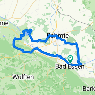
Bad Essen - Waldtour
A cycling route starting in Bad Essen, Lower Saxony, Germany.
Overview
About this route
- 1 h 25 min
- Duration
- 17.5 km
- Distance
- 205 m
- Ascent
- 226 m
- Descent
- 12.3 km/h
- Avg. speed
- ---
- Max. altitude

Route photos

Continue with Bikemap
Use, edit, or download this cycling route
You would like to ride Bad Essen - Waldtour or customize it for your own trip? Here is what you can do with this Bikemap route:
Free features
- Save this route as favorite or in collections
- Copy & plan your own version of this route
- Sync your route with Garmin or Wahoo
Premium features
Free trial for 3 days, or one-time payment. More about Bikemap Premium.
- Navigate this route on iOS & Android
- Export a GPX / KML file of this route
- Create your custom printout (try it for free)
- Download this route for offline navigation
Discover more Premium features.
Get Bikemap PremiumFrom our community
Other popular routes starting in Bad Essen
 Bad Essen im Süden
- Distance
- 42.2 km
- Ascent
- 464 m
- Descent
- 463 m
- Location
- Bad Essen, Lower Saxony, Germany
 Auf den Spuren der Familie von Bussche (So, 07.07.2024)
- Distance
- 23 km
- Ascent
- 32 m
- Descent
- 31 m
- Location
- Bad Essen, Lower Saxony, Germany
 Schlösser Tour - Bad Essen
- Distance
- 15.1 km
- Ascent
- 84 m
- Descent
- 74 m
- Location
- Bad Essen, Lower Saxony, Germany
 Hügeltour II.
- Distance
- 84.6 km
- Ascent
- 881 m
- Descent
- 879 m
- Location
- Bad Essen, Lower Saxony, Germany
 Entlang des Wiehengebirges
- Distance
- 49.1 km
- Ascent
- 45 m
- Descent
- 48 m
- Location
- Bad Essen, Lower Saxony, Germany
 Bad Essen - Kronensee
- Distance
- 37.1 km
- Ascent
- 125 m
- Descent
- 126 m
- Location
- Bad Essen, Lower Saxony, Germany
 Denkmalsweg 1, Bad Essen nach Wehrendorfer Bergstraße 4, Bad Essen
- Distance
- 32.5 km
- Ascent
- 372 m
- Descent
- 322 m
- Location
- Bad Essen, Lower Saxony, Germany
 Bad Essen - Meller Berge
- Distance
- 45.5 km
- Ascent
- 603 m
- Descent
- 603 m
- Location
- Bad Essen, Lower Saxony, Germany
Open it in the app