

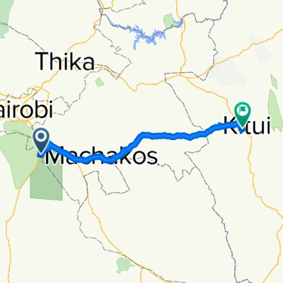
Route from Nairobi-Namanga-Athi River Road, Athi River
A cycling route starting in Athi River, Machakos County, Kenya.
Overview
About this route
- 44 min
- Duration
- 13.8 km
- Distance
- 7,761 m
- Ascent
- 7,758 m
- Descent
- 18.9 km/h
- Avg. speed
- ---
- Max. altitude
Route photos


Continue with Bikemap
Use, edit, or download this cycling route
You would like to ride Route from Nairobi-Namanga-Athi River Road, Athi River or customize it for your own trip? Here is what you can do with this Bikemap route:
Free features
- Save this route as favorite or in collections
- Copy & plan your own version of this route
- Sync your route with Garmin or Wahoo
Premium features
Free trial for 3 days, or one-time payment. More about Bikemap Premium.
- Navigate this route on iOS & Android
- Export a GPX / KML file of this route
- Create your custom printout (try it for free)
- Download this route for offline navigation
Discover more Premium features.
Get Bikemap PremiumFrom our community
Other popular routes starting in Athi River
 Old Mlolongo Road, Athi River to Kibera Access Road, Nairobi
- Distance
- 20.9 km
- Ascent
- 90 m
- Descent
- 0 m
- Location
- Athi River, Machakos County, Kenya
 Mombasa Road, Athi River to Kibera Access Road, Nairobi
- Distance
- 19.6 km
- Ascent
- 100 m
- Descent
- 10 m
- Location
- Athi River, Machakos County, Kenya
 FXV4+4V6, Athi River to JXFW+X34, Kitui
- Distance
- 141.7 km
- Ascent
- 1,580 m
- Descent
- 2,050 m
- Location
- Athi River, Machakos County, Kenya
 Steady ride
- Distance
- 18.1 km
- Ascent
- 158 m
- Descent
- 158 m
- Location
- Athi River, Machakos County, Kenya
 Restful route
- Distance
- 39.2 km
- Ascent
- 252 m
- Descent
- 252 m
- Location
- Athi River, Machakos County, Kenya
 Community Road, Nairobi to Community Road, Nairobi
- Distance
- 9.1 km
- Ascent
- 62 m
- Descent
- 51 m
- Location
- Athi River, Machakos County, Kenya
 Recovered Route
- Distance
- 19.4 km
- Ascent
- 293 m
- Descent
- 152 m
- Location
- Athi River, Machakos County, Kenya
 Police Road, Mavoko to Police Road, Mavoko
- Distance
- 23.3 km
- Ascent
- 159 m
- Descent
- 160 m
- Location
- Athi River, Machakos County, Kenya
Open it in the app