

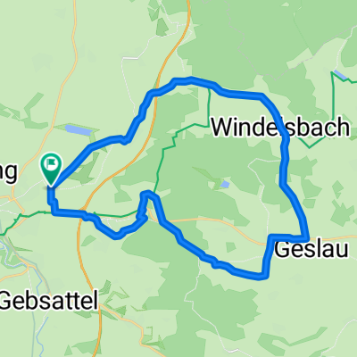
5 Rothenburg ob de Tauber - Erlangen
A cycling route starting in Rothenburg upon Tauber, Bavaria, Germany.
Overview
About this route
- -:--
- Duration
- 83.3 km
- Distance
- 645 m
- Ascent
- 783 m
- Descent
- ---
- Avg. speed
- 511 m
- Avg. speed

Route quality
Waytypes & surfaces along the route
Waytypes
Quiet road
28.2 km
(34 %)
Track
22.3 km
(27 %)
Surfaces
Paved
39.7 km
(48 %)
Unpaved
12.4 km
(15 %)
Asphalt
31.4 km
(38 %)
Gravel
10.5 km
(13 %)
Route highlights
Points of interest along the route
Point of interest after 16 km
Edeka und Norma nach 15 KM
Point of interest after 18.9 km
Metzgerei Klenk nach 19 KM

Point of interest after 27.6 km
Hotel zum Storchen nach 29 KM
Point of interest after 48.8 km
Gasthaus im Aurachgrund ab 11:00 Mittwoch Ruhetag nach 49 KM
Point of interest after 55.8 km
Netto nach 55 KM
Point of interest after 70.2 km
REWE nach 69 KM in Herzogenaurach
Point of interest after 71.3 km
Norma nach 71 KM
Point of interest after 79.3 km
IRINA-Lebensmittel nach 79 KM
Point of interest after 80.2 km
Lidl und EDEKA nach 80 KM
Continue with Bikemap
Use, edit, or download this cycling route
You would like to ride 5 Rothenburg ob de Tauber - Erlangen or customize it for your own trip? Here is what you can do with this Bikemap route:
Free features
- Save this route as favorite or in collections
- Copy & plan your own version of this route
- Split it into stages to create a multi-day tour
- Sync your route with Garmin or Wahoo
Premium features
Free trial for 3 days, or one-time payment. More about Bikemap Premium.
- Navigate this route on iOS & Android
- Export a GPX / KML file of this route
- Create your custom printout (try it for free)
- Download this route for offline navigation
Discover more Premium features.
Get Bikemap PremiumFrom our community
Other popular routes starting in Rothenburg upon Tauber
 Rund um Rothenburg
- Distance
- 23.1 km
- Ascent
- 463 m
- Descent
- 445 m
- Location
- Rothenburg upon Tauber, Bavaria, Germany
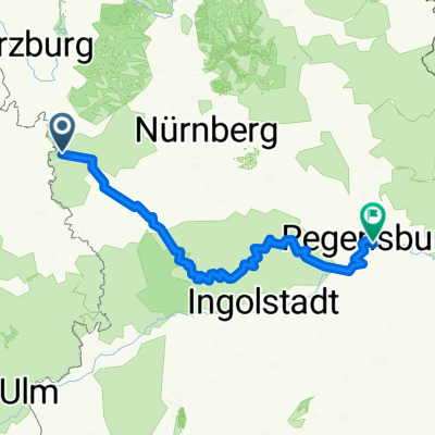 Rothenburg-Regensburg
- Distance
- 263.4 km
- Ascent
- 1,292 m
- Descent
- 1,373 m
- Location
- Rothenburg upon Tauber, Bavaria, Germany
 Route zu Kaufland
- Distance
- 2.6 km
- Ascent
- 115 m
- Descent
- 24 m
- Location
- Rothenburg upon Tauber, Bavaria, Germany
 35_Rothenburg ob der Tauber – Leutershausen
- Distance
- 41.9 km
- Ascent
- 171 m
- Descent
- 168 m
- Location
- Rothenburg upon Tauber, Bavaria, Germany
 Rothenburg-Tauberquelle
- Distance
- 44.7 km
- Ascent
- 278 m
- Descent
- 278 m
- Location
- Rothenburg upon Tauber, Bavaria, Germany
 Taubertal-Panorama
- Distance
- 52.4 km
- Ascent
- 733 m
- Descent
- 895 m
- Location
- Rothenburg upon Tauber, Bavaria, Germany
 Frankenhöhe
- Distance
- 25 km
- Ascent
- 219 m
- Descent
- 224 m
- Location
- Rothenburg upon Tauber, Bavaria, Germany
 Paneuropa radweg (alternative german part)
- Distance
- 36 km
- Ascent
- 498 m
- Descent
- 580 m
- Location
- Rothenburg upon Tauber, Bavaria, Germany
Open it in the app