

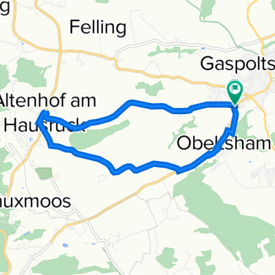
Haager Lies Gaspoltshofen - Haag R23 - Pramwald R21 - Hofkirchen adT - Weibern R17 - R106 Gaspoltshofen
A cycling route starting in Niederthalheim, Upper Austria, Austria.
Overview
About this route
- 1 h 58 min
- Duration
- 43.3 km
- Distance
- 588 m
- Ascent
- 547 m
- Descent
- 21.9 km/h
- Avg. speed
- ---
- Max. altitude

Route quality
Waytypes & surfaces along the route
Waytypes
Quiet road
21.4 km
(50 %)
Cycleway
8.1 km
(19 %)
Surfaces
Paved
10.9 km
(25 %)
Unpaved
0.8 km
(2 %)
Asphalt
10.4 km
(24 %)
Paved (undefined)
0.5 km
(1 %)
Continue with Bikemap
Use, edit, or download this cycling route
You would like to ride Haager Lies Gaspoltshofen - Haag R23 - Pramwald R21 - Hofkirchen adT - Weibern R17 - R106 Gaspoltshofen or customize it for your own trip? Here is what you can do with this Bikemap route:
Free features
- Save this route as favorite or in collections
- Copy & plan your own version of this route
- Sync your route with Garmin or Wahoo
Premium features
Free trial for 3 days, or one-time payment. More about Bikemap Premium.
- Navigate this route on iOS & Android
- Export a GPX / KML file of this route
- Create your custom printout (try it for free)
- Download this route for offline navigation
Discover more Premium features.
Get Bikemap PremiumFrom our community
Other popular routes starting in Niederthalheim
 GKA Radtag 2013
- Distance
- 59.9 km
- Ascent
- 236 m
- Descent
- 236 m
- Location
- Niederthalheim, Upper Austria, Austria
 Gaspoltshofen R106/V1/V2/R17 Trattnach Ursprung R23 Haag R21 Pramtal- R17/R106 zurück n. Gaspoltshofen
- Distance
- 53.4 km
- Ascent
- 1,121 m
- Descent
- 1,128 m
- Location
- Niederthalheim, Upper Austria, Austria
 Hausruckrunde
- Distance
- 62.5 km
- Ascent
- 938 m
- Descent
- 941 m
- Location
- Niederthalheim, Upper Austria, Austria
 Neukirchen-Gaspoldshofen
- Distance
- 25.9 km
- Ascent
- 389 m
- Descent
- 327 m
- Location
- Niederthalheim, Upper Austria, Austria
 Gaspoltshofen - Gmunden
- Distance
- 34.1 km
- Ascent
- 247 m
- Descent
- 259 m
- Location
- Niederthalheim, Upper Austria, Austria
 Rundstrecke Gaspoltshofen - Altenhof
- Distance
- 8 km
- Ascent
- 95 m
- Descent
- 96 m
- Location
- Niederthalheim, Upper Austria, Austria
 Ndth - Gampern - Ndth
- Distance
- 52.3 km
- Ascent
- 593 m
- Descent
- 594 m
- Location
- Niederthalheim, Upper Austria, Austria
 Haager Lies Gaspoltshofen - Haag R23 - Pramwald R21 - Hofkirchen adT - Weibern R17 - R106 Gaspoltshofen
- Distance
- 43.3 km
- Ascent
- 588 m
- Descent
- 547 m
- Location
- Niederthalheim, Upper Austria, Austria
Open it in the app