

Kampinoski Szlak Rowerowy
A cycling route starting in Łomianki, Masovian Voivodeship, Poland.
Overview
About this route
The Kampinoski Szlak Rowerowy is a green cycling route in Poland, marked by a black bicycle on a white background with a green bar below. It is part of the RCN network. More information can be found at Q11734680 and on the Polish Wikipedia page Kampinoski Szlak Rowerowy.
- -:--
- Duration
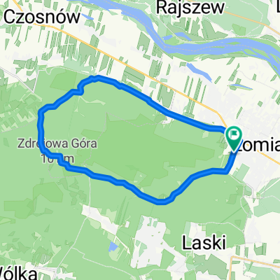
- 129.7 km
- Distance
- 142 m
- Ascent
- 140 m
- Descent
- ---
- Avg. speed
- 103 m
- Max. altitude

Route quality
Waytypes & surfaces along the route
Waytypes
Track
44.1 km
(34 %)
Quiet road
40.2 km
(31 %)
Surfaces
Paved
40.2 km
(31 %)
Unpaved
54.5 km
(42 %)
Asphalt
36.3 km
(28 %)
Ground
32.4 km
(25 %)
Continue with Bikemap
Use, edit, or download this cycling route
You would like to ride Kampinoski Szlak Rowerowy or customize it for your own trip? Here is what you can do with this Bikemap route:
Free features
- Save this route as favorite or in collections
- Copy & plan your own version of this route
- Split it into stages to create a multi-day tour
- Sync your route with Garmin or Wahoo
Premium features
Free trial for 3 days, or one-time payment. More about Bikemap Premium.
- Navigate this route on iOS & Android
- Export a GPX / KML file of this route
- Create your custom printout (try it for free)
- Download this route for offline navigation
Discover more Premium features.
Get Bikemap PremiumFrom our community
Other popular routes starting in Łomianki
 MTB Mazovia 2010 - Łomianki 03.10.2010 (Epilog)
- Distance
- 54.2 km
- Ascent
- 90 m
- Descent
- 88 m
- Location
- Łomianki, Masovian Voivodeship, Poland
 Sobotnia Wycieczka Rowerowa
- Distance
- 53.2 km
- Ascent
- 79 m
- Descent
- 78 m
- Location
- Łomianki, Masovian Voivodeship, Poland
 Kampinoski Szlak Rowerowy
- Distance
- 129.7 km
- Ascent
- 142 m
- Descent
- 140 m
- Location
- Łomianki, Masovian Voivodeship, Poland
 Chata Trapera - Nowy Dwór - Chata Trapera
- Distance
- 55.2 km
- Ascent
- 52 m
- Descent
- 53 m
- Location
- Łomianki, Masovian Voivodeship, Poland
 Łaki i pola :)
- Distance
- 9.3 km
- Ascent
- 9 m
- Descent
- 19 m
- Location
- Łomianki, Masovian Voivodeship, Poland
 P.Kampinos_Dąbrowa-Roztoka-Zaborów_09.05.09
- Distance
- 64.7 km
- Ascent
- 109 m
- Descent
- 109 m
- Location
- Łomianki, Masovian Voivodeship, Poland
 Leki trening MTB cz.1
- Distance
- 19.9 km
- Ascent
- 390 m
- Descent
- 384 m
- Location
- Łomianki, Masovian Voivodeship, Poland
 do palmir
- Distance
- 25.6 km
- Ascent
- 63 m
- Descent
- 64 m
- Location
- Łomianki, Masovian Voivodeship, Poland
Open it in the app