

Strecke: Rund im Odenwald 2004 U23
A cycling route starting in Erbach im Odenwald, Hesse, Germany.
Overview
About this route
Je mehr du hier schreibst, desto hilfreicher ist es für andere User.* Verlauf der Strecke.* Warum gefällt dir diese Route?* Warum empfiehlst du sie?* Was sind die Highlights?* usw.
FB_Addon_TelNo{ height:15px !important; white-space: nowrap !important; background-color: #0ff0ff;}
FB_Addon_TelNo{ height:15px !important; white-space: nowrap !important; background-color: #0ff0ff;}
- -:--
- Duration
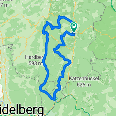
- 84.7 km
- Distance
- 1,190 m
- Ascent
- 905 m
- Descent
- ---
- Avg. speed
- ---
- Avg. speed
Route quality
Waytypes & surfaces along the route
Waytypes
Busy road
41.1 km
(49 %)
Road
19.5 km
(23 %)
Surfaces
Paved
49.7 km
(59 %)
Unpaved
8 km
(9 %)
Asphalt
45.7 km
(54 %)
Gravel
6.1 km
(7 %)
Continue with Bikemap
Use, edit, or download this cycling route
You would like to ride Strecke: Rund im Odenwald 2004 U23 or customize it for your own trip? Here is what you can do with this Bikemap route:
Free features
- Save this route as favorite or in collections
- Copy & plan your own version of this route
- Sync your route with Garmin or Wahoo
Premium features
Free trial for 3 days, or one-time payment. More about Bikemap Premium.
- Navigate this route on iOS & Android
- Export a GPX / KML file of this route
- Create your custom printout (try it for free)
- Download this route for offline navigation
Discover more Premium features.
Get Bikemap PremiumFrom our community
Other popular routes starting in Erbach im Odenwald
 Schmuckertour
- Distance
- 53.3 km
- Ascent
- 730 m
- Descent
- 731 m
- Location
- Erbach im Odenwald, Hesse, Germany
 kleine hügelrunde um erbach
- Distance
- 37.2 km
- Ascent
- 697 m
- Descent
- 689 m
- Location
- Erbach im Odenwald, Hesse, Germany
 Raubacher Runde
- Distance
- 60.4 km
- Ascent
- 970 m
- Descent
- 970 m
- Location
- Erbach im Odenwald, Hesse, Germany
 Von Hüttenthal nach Keilbach
- Distance
- 24 km
- Ascent
- 547 m
- Descent
- 588 m
- Location
- Erbach im Odenwald, Hesse, Germany
 09.08
09.08- Distance
- 30 km
- Ascent
- 490 m
- Descent
- 488 m
- Location
- Erbach im Odenwald, Hesse, Germany
 2. Tour Odenwald Klinge
- Distance
- 104.8 km
- Ascent
- 1,125 m
- Descent
- 1,125 m
- Location
- Erbach im Odenwald, Hesse, Germany
 Westliche Rundtour
- Distance
- 44.3 km
- Ascent
- 602 m
- Descent
- 604 m
- Location
- Erbach im Odenwald, Hesse, Germany
 Odenwald 1
- Distance
- 41.8 km
- Ascent
- 673 m
- Descent
- 648 m
- Location
- Erbach im Odenwald, Hesse, Germany
Open it in the app