
Po Moslavačkoj transverzali
A cycling route starting in Voloder, Sisak-Moslavina County, Croatia.
Overview
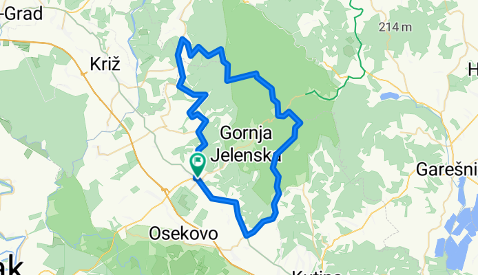
About this route
I rode this tour on 21.05.2011. I mention the date because I know that many things will change soon on the forest sections.
From Popovača to Andigola, the road winds, climbing and descending the vineyard slopes, and those first 25 km quite tired me out.
At the end of the village Andigola, there is a large partisan monument next to which there are tables and benches for a pleasant rest. From there, the road starts to seriously climb towards the peaks and it was freshly covered with large stones the size of a fist so that in some places it is almost impossible to pass without dismounting and pushing.
At two-thirds of the way to Pleterec, where the road reaches its highest point, it turns right towards Jelengrad. There the road is much more pleasant to ride until the junction for the Mjesec summit.
Just before the end of the ascent to Mjesec, there is a 200-meter terribly steep incline (about 25%) which is almost impossible to ride.
At Mjesec, there is a sign to turn right to Humka, and there is also a written notice asking people not to ride bicycles and motorcycles on the forest clearings.
Up to Strma Međa and Kaluđer's grave, the road winds with waves through the forest. It is similar further on to the road connecting Gornja Jelenska and Podgarić, and continues to Pukli Kamen. On this entire stretch, there are many intersections without any signs, so a good sense of orientation is necessary.
From Pukli Kamen to the summit of Humka, there is still a short section of ascent but it is not steep. At Humka, besides the well-known TV tower, there is also a partisan monument, and now a newly built hunting lodge and oven with benches and tables. From Humka follows a long descent to the pond in Mikleuška. The elevation difference here is 280 m.
There are also benches and tables at the pond for rest and relaxation.
From the entrance to the forest at Andigola to the pond in Mikleuška, I covered 27 km and spent 4 full hours. Overall, adding up all the meters ridden uphill, it would certainly be over 1,000 meters. Quite tiring and demanding, primarily due to the surface (gravel, stones, and dirt).
From the pond in Mikleuška to the village itself, you pass through a quarry which is terribly dusty. Deep white dust like flour that turns into mud with a little rain.
From Mikleuška, the road leads to the main road, then via Voloder on the well-known road to Popovača. Altogether, 7 hours of riding.
- -:--
- Duration
- 63.1 km
- Distance
- 0 m
- Ascent
- 0 m
- Descent
- ---
- Avg. speed
- ---
- Max. altitude

Continue with Bikemap
Use, edit, or download this cycling route
You would like to ride Po Moslavačkoj transverzali or customize it for your own trip? Here is what you can do with this Bikemap route:
Free features
- Save this route as favorite or in collections
- Copy & plan your own version of this route
- Sync your route with Garmin or Wahoo
Premium features
Free trial for 3 days, or one-time payment. More about Bikemap Premium.
- Navigate this route on iOS & Android
- Export a GPX / KML file of this route
- Create your custom printout (try it for free)
- Download this route for offline navigation
Discover more Premium features.
Get Bikemap PremiumFrom our community
Other popular routes starting in Voloder
 za jerka
- Distance
- 8.3 km
- Ascent
- 328 m
- Descent
- 265 m
- Location
- Voloder, Sisak-Moslavina County, Croatia
 Po Moslavačkoj transverzali
- Distance
- 63.1 km
- Ascent
- 0 m
- Descent
- 0 m
- Location
- Voloder, Sisak-Moslavina County, Croatia
 Mikleuška to Ulica Vladimira Nazora 1, Garešnica
- Distance
- 29.3 km
- Ascent
- 351 m
- Descent
- 651 m
- Location
- Voloder, Sisak-Moslavina County, Croatia
 ruta duža ex
- Distance
- 25.3 km
- Ascent
- 576 m
- Descent
- 602 m
- Location
- Voloder, Sisak-Moslavina County, Croatia
 Moslavačka ruta 3 izvora-40km
- Distance
- 40 km
- Ascent
- 449 m
- Descent
- 449 m
- Location
- Voloder, Sisak-Moslavina County, Croatia
 ruta 5 srednjovjekovnih župa Jugozapadne Moslavine(moslavačka gora)
- Distance
- 39.6 km
- Ascent
- 110 m
- Descent
- 109 m
- Location
- Voloder, Sisak-Moslavina County, Croatia
 Stazama praslonova
- Distance
- 29.8 km
- Ascent
- 494 m
- Descent
- 494 m
- Location
- Voloder, Sisak-Moslavina County, Croatia
 ruta kraća ex
- Distance
- 15.1 km
- Ascent
- 366 m
- Descent
- 365 m
- Location
- Voloder, Sisak-Moslavina County, Croatia
Open it in the app